40 major glaciers in danger of melting
Glaciers are formations of densely packed ice that cover much of Greenland and Antarctica, as well as mountain ranges around the world. Some of them formed more than 10,000 years ago when the last glacial period—the tail end of the most recent Ice Age—ended. Some alpine (mountain) glaciers are sources of freshwater, and, in some regions, provide substantial amounts of the water people consume. Glaciers form and grow when snowfall is heavy enough to compress into solid ice, and can even flow downhill at a very slow pace.
But glaciers are threatened by the rise in global temperatures due to human activity, through melting or sublimation (ice going directly from solid to vapor without becoming liquid first) and because they aren't being replenished at their usual rates. This has many profound consequences, some of which feed back into the general problem of climate change. Where glaciers are melting into the ocean, they contribute to sea-level rise. Drastic loss of ice also decreases Earth's albedo, the amount of light the planet reflects back into space, which increases global temperatures even more. And alpine glacial melting affects the water cycle for entire regions, impacting our water supply.
To track the problem, the World Glacier Monitoring Service (WGMS) compiled data from 1919 to 2019 in its Fluctuations of Glaciers Database from a variety of scientific sources and researchers in over 30 countries. While the database was originally established to understand ice ages of Earth's past, today WGMS draws on decades of observations to understand the present and future of glaciers under climate change. Stacker took the February 2019 edition of the database and picked 40 glaciers for which WGMS has at least 30 years of ongoing measurements, using the Fluctuations of Glaciers Database to estimate the accumulated mass loss over the time of observation. Unfortunately, that means many extremely important glaciers in the Southern Hemisphere and Central Asia are not included due to the lack of long-term observations.
This story uses a standard glacier measurement: the mass balance, which is the total loss of ice from a glacier in a given period of time, written in terms of the "millimeter water equivalent" or mm w.e. In plain terms, 1 kilogram of water spreads out over a square meter to the depth of 1 millimeter, so mm w.e. provides both the mass of the ice loss and an estimate of how much of the glacier is gone. It's important to note that all these measurements involve absolute ice loss, without regard to the original size of the glacier. That means some glaciers might seem less affected, but because they started off smaller, their decline is all the more drastic.
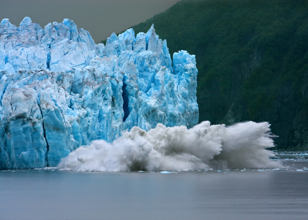
Gulkana
- Mountain range: Alaska (United States)
- Years studied: 1966 to 2017
- 30-year cumulative mass change: -27,334 mm w.e. (#15 highest mass loss)
- Full mass balance plot and other info
Gulkana Glacier is a glacier filling several valleys in the east-central Alaska Range in the state of Alaska. This is one of the essential reference glaciers, with observations and mass balance measurements taken every year for more than 50 years. In all but eight of those years, Gulkana has lost ice, including every year since 2000.
Wolverine
- Mountain range: Alaska (United States)
- Years studied: 1966 to 2017
- 30-year cumulative mass change: -22,896 mm w.e. (#21 highest mass loss)
- Full mass balance plot and other info
Wolverine Glacier is also in Alaska, in the southern coastal mountains of the Kenai Peninsula. Its location means it sees more snowfall than inland glaciers, and it also has been tracked for more than 50 years. Only two years since 2000 show Wolverine Glacier growing; the other years more than balance that, giving it a substantial net loss of ice.
White
- Mountain range: Arctic Canada North (Canada)
- Years studied: 1960 to 2017
- 30-year cumulative mass change: -19,564 mm w.e. (#26 highest mass loss)
- Full mass balance plot and other info
Axel Heiberg Island, far in the north of Nunavut, Canada, is home to White Glacier. This glacier is 400 meters thick in some places, and because of the arid conditions above the Arctic Circle receives very little new snow. Since monitoring the White Glacier began in 1960, the mass loss has increased dramatically, with a noticeable downward trend since 2000.
Melville South Ice Cap
- Mountain range: Arctic Canada North (Canada)
- Years studied: 1963 to 2017
- 30-year cumulative mass change: -13,286 mm w.e. (#34 highest mass loss)
- Full mass balance plot and other info
An ice cap is a type of glacier that covers one or more mountains or volcanoes. One of the WGMS reference glaciers is the Melville South Ice Cap on Melville (Iluliaq) Island, located in Canada's Northwest territories. In absolute terms, this glacier hasn't been hit as hard as some others, but mass loss, especially over the past two decades, has taken a heavy toll on the ice cap's total size.
Meighen Ice Cap
- Mountain range: Arctic Canada North (Canada)
- Years studied: 1960 to 2017
- 30-year cumulative mass change: -8,271 mm w.e. (#38 highest mass loss)
- Full mass balance plot and other info
The Meighen Ice Cap covers much of Meighen Island in the Qikiqtaaluk Region of Nunavut. As with many other Arctic island glaciers, ice loss from the Meighen Ice Cap contributes to sea-level rise, since there's nowhere else for the water to go but the ocean.
Devon Ice Cap NW
- Mountain range: Arctic Canada North (Canada)
- Years studied: 1961 to 2017
- 30-year cumulative mass change: -9,898 mm w.e. (#37 highest mass loss)
- Full mass balance plot and other info
Devon (Tallurutit) Island, also in the Qikiqtaaluk Region of Nunavut, is the largest unpopulated island in the world. The Devon Ice Cap NW is one part of a large mass of ice covering the eastern end of the island. Since 1990, only three years have seen increases in glacier mass, with dramatic ice loss visible especially since 2000.
Garabashi
- Mountain range: Caucasus, Middle East (Russia)
- Years studied: 1984 to 2018
- 30-year cumulative mass change: -15,364 mm w.e. (#31 highest mass loss)
- Full mass balance plot and other info
Shifting our gaze around the world, Garabashi is a glacier in the Caucasus mountains on the southern slope of Mt. Elbrus in Russia. Scientists have tracked the mass balance since the early 1980s and measured the extent of the ice since before 1900. As a result, we know Garabashi has retreated by more than 1.5 kilometers since the first data were collected.
Djankuat
- Mountain range: Caucasus, Middle East (Russia)
- Years studied: 1968 to 2018
- 30-year cumulative mass change: -20,861 mm w.e. (#25 highest mass loss)
- Full mass balance plot and other info
Djankuat is a valley glacier in the northern Caucasus mountains in Russia, roughly on the other side of the ridge from Garabashi. While the glacier has advanced and retreated since measurements began in the late 1800s, Djankuat has been in full retreat since 2005 with a net mass balance loss nearly every year since the early 1990s.
Ts. Tuyuksuyskiy
- Mountain range: Central Asia (Kazakhstan)
- Years studied: 1957 to 2018
- 30-year cumulative mass change: -19,238 mm w.e. (#27 highest mass loss)
- Full mass balance plot and other info
Tsentralniy Tuyuksuyskiy, also known as Tuyuksu, is located in the Tien Shan Mountains of Kazakhstan. Even though the land surrounding Tsentralniy Tuyuksuyskiy is permafrost, scientists have recorded a mass balance loss almost every year since they started measuring in the 1950s. The measurements reveal that the glacier front has retreated by over a kilometer in the last century.
Urumqi Glacier No. 1
- Mountain range: Central Asia (China)
- Years studied: 1959 to 2018
- 30-year cumulative mass change: -14,976 mm w.e. (#32 highest mass loss)
- Full mass balance plot and other info
The Tien Shan mountains run across the borders of several nations and are also home to Urumqi Glacier No. 1. Since observations began in 1959, this glacier has melted dramatically, splitting into two distinct glaciers as the ice retreated.
Gries
- Mountain range: Central Europe (Switzerland)
- Years studied: 1962 to 2018
- 30-year cumulative mass change: -41,768 mm w.e. (#8 highest mass loss)
- Full mass balance plot and other info
Griesgletscher (Gries Glacier) lies in the Swiss Alps on the Italian border. Melt from the glacier supplies water and hydroelectric power to northern Italy, but thanks to climate change, the glacier has lost mass every year since 1980. In addition, the glacier front has retreated nearly 3 kilometers since 1850, with fully half of that retreat occurring since 1950.
Silvretta
- Mountain range: Central Europe (Switzerland)
- Years studied: 1919 to 2018
- 30-year cumulative mass change: -32,619 mm w.e. (#12 highest mass loss)
- Full mass balance plot and other info
Scientists have been monitoring the mass balance of Silvrettagletscher (Silvretta Glacier) for more than a century now, providing some of the longest-running data on any glacier in the world. This small glacier lies on the Swiss-Austrian border in the Alps, providing a clear picture of how climate change has accelerated ice mass loss in the past few decades.
Giétro
- Mountain range: Central Europe (Switzerland)
- Years studied: 1967 to 2018
- 30-year cumulative mass change: -34,591 mm w.e. (#11 highest mass loss)
- Full mass balance plot and other info
Largely due to their proximity to European population centers, Swiss Alps glaciers have some of the most detailed studies. Glacier du Giétro in Switzerland was first studied in the context of the construction of a hydroelectric power plant, but data collected since the late 1960s show some of the highest mass loss anywhere in the world.
Allalin
- Mountain range: Central Europe (Switzerland)
- Years studied: 1956 to 2018
- 30-year cumulative mass change: -22,375 mm w.e. (#22 highest mass loss)
- Full mass balance plot and other info
Allalingletscher (Allalin Glacier) is a high-elevation glacier in the southern Swiss Alps, tracked since the late 1950s. In addition to the high mass loss, Allalin has been in nearly continuous decline since 1980, with the glacier front retreating more than a kilometer up the valley than it was in the 19th century.
Caresèr
- Mountain range: Central Europe (Italy)
- Years studied: 1967 to 2018
- 30-year cumulative mass change: -50,442 mm w.e. (#5 highest mass loss)
- Full mass balance plot and other info
Caresèr Glacier in the Italian Alps has been hit particularly hard by climate change, exhibiting mass balance loss since 1980. Researchers have been able to identify specific feedback effects for Caresèr, including warmer winters and increased sunlight absorption on the surrounding bare ground. The glacier has retreated nearly 1.2 kilometers since 1900, a process that seems to be accelerating since the start of the 21st century.
Sarennes
- Mountain range: Central Europe (France)
- Years studied: 1949 to 2019
- 30-year cumulative mass change: -60,807 mm w.e. (#4 highest mass loss)
- Full mass balance plot and other info
The French Alps are home to a cluster of glaciers that have been hit very hard by the warming climate. That includes Sarennes, a glacier that has lost a huge amount of ice nearly every year since 1949, making it the fourth highest-loss reference glacier in the WGMS database.
Saint Sorlin
- Mountain range: Central Europe (France)
- Years studied: 1957 to 2017
- 30-year cumulative mass change: -44,976 mm w.e. (#6 highest mass loss)
- Full mass balance plot and other info
Saint Sorlin is a neighboring glacier to Sarennes in the French Alps. The glacier has been losing mass every year but two in the past 30 years, and it has retreated almost a kilometer up the valley since the 1920s.
Argentière
- Mountain range: Central Europe (France)
- Years studied: 1976 to 2017
- 30-year cumulative mass change: -30,735 mm w.e. (#13 highest mass loss)
- Full mass balance plot and other info
Argentière is a valley glacier in the French Alps, and like other alpine glaciers is suffering from warmer winters with less snowfall. Due to its location, scientists have been able to extrapolate the growth and retreat of the glacier back to the 17th century. That demonstrates clearly that the current mass loss is a modern trend linked to other climate change effects, rather than part of a natural cycle.
Hintereisferner
- Mountain range: Central Europe (Austria)
- Years studied: 1953 to 2018
- 30-year cumulative mass change: -42,899 mm w.e. (#7 highest mass loss)
- Full mass balance plot and other info
Farther east in the Austrian Alps, Hintereisferner is a valley glacier running parallel to the Austrian-Italian border. The glacier has experienced mass loss nearly every year of observation, a trend which has been getting stronger since 1980. In addition, Hintereisferner has retreated almost 3 kilometers up the valley since the late 18th century.
Kesselwandferner
- Mountain range: Central Europe (Austria)
- Years studied: 1953 to 2018
- 30-year cumulative mass change: -37,458 mm w.e. (#10 highest mass loss)
- Full mass balance plot and other info
Kesselwandferner is a high altitude glacier in the Austrian Alps, which has retreated more than a kilometer since the early 20th century. In addition to the large mass loss, scientists have determined that Kesselwandferner is measurably thinner than it was in the 1970s.
You may also like: 25 terms you should know to understand the climate change conversation
Vernagtferner
- Mountain range: Central Europe (Austria)
- Years studied: 1965 to 2018
- 30-year cumulative mass change: -27,315 mm w.e. (#16 highest mass loss)
- Full mass balance plot and other info
Vernagtferner is another Austrian Alps glacier, which fills a relatively flat plateau. Similar to many of the other endangered glaciers on this list, Vernagtferner has only had one year of growth since 1980, a figure all the more striking because it tended to grow in previous decades of measurement. In fact, it grew during the earliest observation period around the turn of the 20th century, but it lost all its gains and has retreated more than 1.5 kilometers since.
Rabots Glaciär
- Mountain range: Scandinavia (Sweden)
- Years studied: 1946 to 2018
- 30-year cumulative mass change: -3,154 mm w.e. (#40 highest mass loss)
- Full mass balance plot and other info
Moving above the Arctic Circle again, Rabots Glaciär sits on the slope of Kebnekaise, the highest mountain in Sweden. Rabots has been sporadically monitored for mass loss and glacier front movement since the early 20th century, with yearly measurements starting in the early 1980s. Since observations began, the glacier has retreated nearly a kilometer and lost a substantial amount of ice thickness.
Storglaciaeren
- Mountain range: Scandinavia (Sweden)
- Years studied: 1946 to 2018
- 30-year cumulative mass change: -3,231 mm w.e. (#39 highest mass loss)
- Full mass balance plot and other info
Storglaciaeren is a valley glacier also located in the north of Sweden. While the glacier's mass balance has both increased and decreased, the losses have been cumulatively larger than the gains. Making the trend clearer, Storglaciaeren's front has retreated up the mountain by about 600 meters over the past century.
Engabreen
- Mountain range: Scandinavia (Norway)
- Years studied: 1970 to 2018
- 30-year cumulative mass change: -109,800 mm w.e. (#1 highest mass loss)
- Full mass balance plot and other info
The western Svartisen Ice Cap covers part of the mountain range in northwestern Norway, and the Engabreen glacier extends from it much like a river flowing from a lake. Extrapolating from observations reaching back to 1600, scientists estimate the glacier grew substantially before climate change hit it, causing it to retreat by more than 2 kilometers during the 20th and 21st centuries.
Nigardsbreen
- Mountain range: Scandinavia (Norway)
- Years studied: 1962 to 2018
- 30-year cumulative mass change: -88,274 mm w.e. (#2 highest mass loss)
- Full mass balance plot and other info
Nigardsbreen Glacier is a river of ice flowing from the Jostedalsbreen Ice Cap in central Norway. Scientists began measuring the glacier length in 1899 and the mass balance in 1962, showing Nigardsbreen has retreated more than 2.5 kilometers.
Rembesdalskaaka
- Mountain range: Scandinavia (Norway)
- Years studied: 1963 to 2018
- 30-year cumulative mass change: -64,633 mm w.e. (#3 highest mass loss)
- Full mass balance plot and other info
Some glaciers act as natural dams for lakes, which can fail when they are weakened either through natural variations or global warming. Rembesdalskaaka in Norway is one such glacier dam, which has given way several times since 2014, leading to floods downstream. Since these outbursts were the first since 1938, it's another sign of how climate change is affecting glaciers.
Ålfotbreen
- Mountain range: Scandinavia (Norway)
- Years studied: 1963 to 2018
- 30-year cumulative mass change: -26,412 mm w.e. (#18 highest mass loss)
- Full mass balance plot and other info
The Ålfotbreen ice cap is the westernmost glacier in Norway, with two major outflow glaciers. Scientists gauge the overall health of Ålfotbreen by measuring the changes in these outflows: the mass balance, ice thickness, and position of the glacier fronts. Until the early 1990s, the ice cap grew more than it shrank, but the trend has reversed since.
Hellstugubreen
- Mountain range: Scandinavia (Norway)
- Years studied: 1962 to 2018
- 30-year cumulative mass change: -25,182 mm w.e. (#20 highest mass loss)
- Full mass balance plot and other info
Located in the central mountains of Norway, Hellstugubreen has been mapped many times, including using laser altitude measurements. The glacier has retreated nearly 1.2 kilometers since it was mapped and lost a substantial amount of ice thickness since the 1970s.
Storbreen
- Mountain range: Scandinavia (Norway)
- Years studied: 1949 to 2018
- 30-year cumulative mass change: -12,955 mm w.e. (#36 highest mass loss)
- Full mass balance plot and other info
Over 70 years of mass balance data make Storbreen in central Norway one of the longest-studied glaciers. As with many reference glaciers in the WGMS database, Storbreen has experienced an increasing amount of mass loss since 1990, with a marked downturn in the 21st century. The glacier has also retreated nearly 1.5 kilometers since 1900.
Graasubreen
- Mountain range: Scandinavia (Norway)
- Years studied: 1962 to 2018
- 30-year cumulative mass change: -13,001 mm w.e. (#35 highest mass loss)
- Full mass balance plot and other info
Gråsubreen is a small glacier on the western side of the mountains in central Norway, which makes it less exposed to the weather fluctuations from the ocean. As a result, the glacier's size doesn't fluctuate as much as glaciers in wetter conditions, making the downward trends in size due to climate change easier to spot.
Echaurren Norte
- Mountain range: Southern Andes (Chile)
- Years studied: 1976 to 2017
- 30-year cumulative mass change: -21,177 mm w.e. (#23 highest mass loss)
- Full mass balance plot and other info
The only Southern Hemisphere reference glacier in our sample is Echaurren Norte in the Chilean Andes east of Santiago. As noted in the introduction, this isn't because these glaciers aren't important, but simply because many researchers didn't focus on glaciers outside of North America and Europe until recently. The mass balance shows an increased loss of ice since 1990, which reflects more significant problems for the region due to climate change.
Austre Broeggerbreen
- Mountain range: Svalbard (Svalbard and Jan Mayen)
- Years studied: 1967 to 2018
- 30-year cumulative mass change: -17,037 mm w.e. (#30 highest mass loss)
- Full mass balance plot and other info
The islands making up Svalbard in the Arctic Ocean are home to several glaciers, including the valley glacier Austre Broeggerbreen in the northwest of the largest island. The land around is permanently frozen and experiences relatively little precipitation. However, Austre Broeggerbreen has only experienced a net gain in mass balance three years since scientists started taking measurements in 1967, and the glacier has lost a considerable amount of ice thickness.
Midtre Lovénbreen
- Mountain range: Svalbard (Svalbard and Jan Mayen)
- Years studied: 1968 to 2018
- 30-year cumulative mass change: -13,794 mm w.e. (#33 highest mass loss)
- Full mass balance plot and other info
Midtre Lovénbreen is another valley glacier on Svalbard, albeit one with slightly more temperate conditions. Similarly to Austre Broeggerbreen, Midtre Lovénbreen has lost ice all but five years since observations began, a sign that climate change impacts are significant—even in places far from where carbon emissions are highest.
Lemon Creek
- Mountain range: Western Canada & USA (United States)
- Years studied: 1953 to 2018
- 30-year cumulative mass change: -28,344 mm w.e. (#14 highest mass loss)
- Full mass balance plot and other info
Returning once more to Alaska, the Lemon Creek Glacier north of Juneau has been observed since 1953. During that time, the glacier has lost far more ice than it has gained, and its proximity to the ocean means its retreat contributes to sea-level rise. Lemon Creek Glacier has also become measurably thinner, as measured between the 1940s and 2000.
Rainbow
- Mountain range: Western Canada & USA (United States)
- Years studied: 1984 to 2018
- 30-year cumulative mass change: -17,323 mm w.e. (#29 highest mass loss)
- Full mass balance plot and other info
Rainbow Glacier is located on the northeast side of Mt. Baker in Washington state. While the mass balance has fluctuated considerably since observations began, Rainbow has, on average, been losing more ice than it gains, and since the mid-1980s, it has been retreating.
Columbia
- Mountain range: Western Canada & USA (United States)
- Years studied: 1984 to 2018
- 30-year cumulative mass change: -18,281 mm w.e. (#28 highest mass loss)
- Full mass balance plot and other info
Columbia Glacier is a "cirque" glacier, meaning ice forming in a semicircular depression often on the side of a mountain or range, in this case, a basin flanked by four mountains in Washington. As with Rainbow Glacier, Columbia's mass balance has gone up and down (possibly due to the amount of precipitation), but the mass has diminished more than it's grown.
South Cascade
- Mountain range: Western Canada & USA (United States)
- Years studied: 1953 to 2017
- 30-year cumulative mass change: -21,098 mm w.e. (#24 highest mass loss)
- Full mass balance plot and other info
South Cascade Glacier is located below Sentinel Peak in the Cascade Mountains of Washington. Since scientists began taking measurements in the early 1950s, South Cascade has experienced far more ice loss than it has gained, with years of the increase coming fewer and farther between. Additionally, the head of the glacier has retreated 3 kilometers since the late 19th century.
Peyto
- Mountain range: Western Canada & USA (Canada)
- Years studied: 1966 to 2017
- 30-year cumulative mass change: -26,127 mm w.e. (#19 highest mass loss)
- Full mass balance plot and other info
Peyto Glacier in western Alberta in Canada flows down from the Wapta Ice Field, which itself provides water to major regional rivers. Peyto experienced mass loss every year but five years between 1966 and 2017. With such significant losses, scientists are concerned the whole thing might disappear within decades. The glacier front has also melted back more than 2 kilometers since the 1800s, with a corresponding drastic decrease in ice thickness.
Helm
- Mountain range: Western Canada & USA (Canada)
- Years studied: 1975 to 2017
- 30-year cumulative mass change: -39,729 mm w.e. (#9 highest mass loss)
- Full mass balance plot and other info
Helm Glacier is in the Pacific Coast Range of mountains north of Vancouver in British Columbia. Like Peyto Glacier, it is shrinking rapidly, with concerns that it might melt completely, based on mass loss measurements. Helm has also retreated more than a kilometer since mapped in the late 1800s.
Place
- Mountain range: Western Canada & USA (Canada)
- Years studied: 1965 to 2017
- 30-year cumulative mass change: -26,886 mm w.e. (#17 highest mass loss)
- Full mass balance plot and other info
Not far away from Helm is Place Glacier, which is a source of water for nearby rivers. As with other western Canadian glaciers, Place has experienced tremendous mass loss over the past 50 years, with implications for the entire region. Since this is a part of Canada hit hard by recent wildfires, the glacier loss is just one symptom of climate change, reflecting how the world as a whole is damaged by human shortsightedness.