County with the most severe weather in every state
Weather is often a go-to conversation filler or ice-breaker. When people don't know what else to say, they gripe about the heat or the cold or the rain or the snow. But severe weather is far more than an inconvenience, and it can be a matter of life or death.
Take thunderstorms. There are roughly 100,000 thunderstorms every year in the United States, and 1 in 10 is considered severe. They cause flash floods, spark fires, and create hail, killing more people each year than do tornadoes, lightning, or hurricanes. Severe weather is growing more intense as well. Flash floods tear through dry waterbeds, city streets, and sewer drains at breakneck speed. But in developed urban areas, rain falls on impervious surfaces like sidewalks, parking lots, and driveways. Without land to absorb it, the water inundates roadways, culverts, and underpasses. Hail storms are expected to become more dangerous as the planet keeps overheating. Researchers predict climate change will mean fewer days of hail ahead, but an increase in the size of hailstones, making them more destructive and more lethal.
Stacker set out to find the places in the United States that have the most severe weather. Using data from the National Oceanic and Atmospheric Administration, Stacker sorted a decade of storm events large and small from 2010 to 2020, weighing all of them equally, and created a list of counties with the most severe weather in every state.
You think your weather is bad? Take a look at the worst weather in the country.
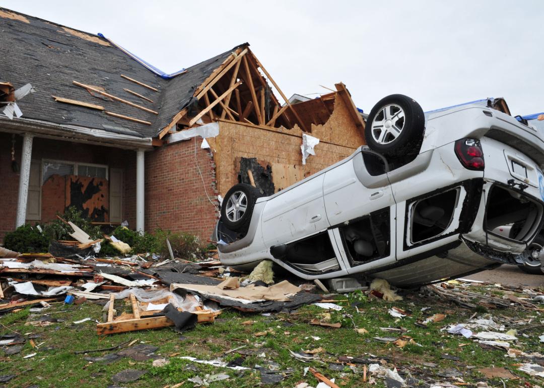
Alabama: Lauderdale County
- Severe weather events (2010–2020): 800 (72.7 per year)
- Most frequent events:
--- #1. Thunderstorm wind (47.4 per year)
--- #2. Flash flood (5.1 per year)
--- #3. Hail (4.7 per year)
Located in northern Alabama, Lauderdale County sits in the heart of so-called Dixie Alley that is prone to high wind and tornado-bearing thunderstorms. Its location close to the mild humid air of the Gulf of Mexico and the jet stream means atmospheric triggers like low-pressure systems produce powerful thunderstorms.
Alaska: Juneau Borough and Northern Admiralty Island
- Severe weather events (2010–2020): 102 (9.3 per year)
- Most frequent events:
--- #1. High Wind (5.5 per year)
--- #2. Winter Storm (3.2 per year)
--- #3. Heavy snow (0.5 per year)
While Juneau Borough and Northern Admiralty Island get high winds and winter storms, its temperatures tell the most dramatic story. Daytime highs in summer typically hit the low- to mid-60s, winter temperatures average 29 degrees Fahrenheit, the thermometer falls below freezing more than 100 nights a year, and for an average of a month every year, the mercury never goes above freezing.
Arizona: Maricopa County
- Severe weather events (2010–2020): 883 (80.3 per year)
- Most frequent events:
--- #1. Thunderstorm wind (40.1 per year)
--- #2. Flash flood (22.2 per year)
--- #3. Heavy rain (8.3 per year)
Flash floods in Maricopa County, home to Phoenix, are the result of storm runoff from mountains that moves quickly through dry washes and riverbeds. Local authorities say a mere 6 inches of moving water can knock a person off their feet, and moving water a foot deep can wash away a car. Arizona has what is known as the "Stupid Motorist Law," under which drivers who become stranded in flooded roadways after driving around barricades may be charged for the expense of being rescued.
Arkansas: Pulaski County
- Severe weather events (2010–2020): 611 (55.5 per year)
- Most frequent events:
--- #1. Thunderstorm wind (16.5 per year)
--- #2. Hail (13.0 per year)
--- #3. Flash flood (9.4 per year)
Pulaski County, home to Little Rock, frequently gets severe thunderstorms that create tornadoes. In 2014, the Mayflower/Vilonia tornado tore 41 miles through Pulaski and two other counties, killing 16 people and injuring nearly 200 others. It was the state's deadliest tornado since 1968.
California: San Bernardino County
- Severe weather events (2010–2020): 544 (49.5 per year)
- Most frequent events:
--- #1. Flash flood (32.5 per year)
--- #2. Flood (4.3 per year)
--- #3. Thunderstorm wind (4.1 per year)
Southern California, where San Bernardino County is located, is susceptible to flash floods made worse by inadequate drainage systems and impermeable surfaces such as streets and parking lots that do not allow water to be absorbed. Outdated management strategies aimed to route floodwaters to the ocean, but experts say a better approach is restoring wetlands and river corridors and refilling aquifers. San Bernardino County authorities advise residents in the flood-prone areas to build retaining walls, raise furnace and electrical panels above potential flood levels, and keep a supply of sandbags on hand.
Colorado: El Paso County
- Severe weather events (2010–2020): 905 (82.3 per year)
- Most frequent events:
--- #1. Hail (59.2 per year)
--- #2. Flash flood (10.1 per year)
--- #3. Heavy rain (5.9 per year)
El Paso County, where Colorado Springs is located, lies along the Colorado Front Range where hail storms are frequent. At the region's higher elevation, hail falls faster and can do more damage than in lower elevations. Spring and summer are considered hail season, with the largest hailstones in April, May, and June when thunderstorm updrafts are biggest.
Connecticut: Litchfield County
- Severe weather events (2010–2020): 274 (24.9 per year)
- Most frequent events:
--- #1. Thunderstorm wind (15.7 per year)
--- #2. Hail (4.6 per year)
--- #3. Flash flood (1.6 per year)
Picturesque, hilly and wooded, Litchfield County is a popular getaway location nestled in northwestern Connecticut. Its worst weather comes in the form of thunderstorms which typically, due to all the area trees, knock out electrical power to residents. Experts say the area needs to modernize with smart meters, buried wiring, and microgrids that can isolate areas of power failure and supplies.
Delaware: New Castle County
- Severe weather events (2010–2020): 553 (50.3 per year)
- Most frequent events:
--- #1. Thunderstorm wind (16.4 per year)
--- #2. Winter weather (5.5 per year)
--- #3. Flash flood (5.4 per year)
New Castle County, Delaware, where Wilmington is situated, lies along the Delaware River across from New Jersey. Particularly in summer, thunderstorms are common, with heavy rain.
Florida: Duval County
- Severe weather events (2010–2020): 658 (59.8 per year)
- Most frequent events:
--- #1. Thunderstorm wind (24.7 per year)
--- #2. Heavy rain (10.7 per year)
--- #3. Hail (8.2 per year)
Duval County encompasses Jacksonville, Florida, where in February 2020 a powerful storm front killed at least four people. Winds of up to 70 mph damaged homes and trees and knocked out power to some 172,000 customers.
Georgia: Chatham County
- Severe weather events (2010–2020): 398 (36.2 per year)
- Most frequent events:
--- #1. Thunderstorm wind (25.0 per year)
--- #2. Hail (5.6 per year)
--- #3. Flash flood (2.4 per year)
The weather in Chatham County, which consists of the city of Savannah, is called humid subtropical, and humidity is particularly high from May through September. Average daytime high temperatures in the low 90s in July and August cause plenty of thunderstorms to build.
Hawaii: Hawaii County
- Severe weather events (2010–2020): 463 (42.1 per year)
- Most frequent events:
--- #1. Heavy rain (36.1 per year)
--- #2. Flash flood (4.7 per year)
--- #3. Funnel cloud (0.4 per year)
Hawaii County is known as the Big Island, where Hilo is the nation's wettest city with more than 130 inches of rain a year. Hilo is located on the windward east side of the island, where moisture blown onto land in trade winds condenses into clouds and rain. Hilo gets 10 to 40 times more rain than do the island's driest sections.
Idaho: Bonneville County
- Severe weather events (2010–2020): 121 (11.0 per year)
- Most frequent events:
--- #1. Thunderstorm wind (3.5 per year)
--- #2. Hail (1.0 per year)
--- #3. Funnel cloud (0.6 per year)
Idaho's Bonneville County gets funnel clouds, spinning columns of air that reach down from cumulus or cumulonimbus clouds overhead. Unlike tornadoes, funnel clouds do not touch the ground.
Illinois: Cook County
- Severe weather events (2010–2020): 861 (78.3 per year)
- Most frequent events:
--- #1. Thunderstorm wind (28.2 per year)
--- #2. Hail (17.7 per year)
--- #3. Flash flood (7.6 per year)
Proximity to Lake Michigan means Cook County, which includes Chicago, gets unsettling severe weather known as training thunderstorms. Unlike typical quick single-cell thunderstorms, training thunderstorms can repeatedly build in the same areas for hours and produce serious flooding. The name comes from the resemblance to train cars on railroad tracks.
Indiana: Gibson County
- Severe weather events (2010–2020): 417 (37.9 per year)
- Most frequent events:
--- #1. Flood (12.9 per year)
--- #2. Dense Fog (3.6 per year)
--- #3. Thunderstorm wind (3.5 per year)
Gibson County, Indiana, sits along the Wabash River, the scene of one of the worst floods in state history in 1913. As heavy rains fell across the state, the Wabash River brimming with floodwater grew almost seven miles wide. The flooding was followed by food shortages and typhoid. The death toll was between 100 and 200 people.
Iowa: Polk County
- Severe weather events (2010–2020): 494 (44.9 per year)
- Most frequent events:
--- #1. Heavy rain (26.8 per year)
--- #2. Thunderstorm wind (23.5 per year)
--- #3. Hail (16.7 per year)
Polk County is centrally located in Iowa which has been getting increasing amounts of rain in recent years, a change that state officials and experts link to climate change. The rains impact the state's agricultural economy, washing away young plants, eroding soil away, and flooding cropland. They also bring mosquitoes, residents note.
Kansas: Sedgwick County
- Severe weather events (2010–2020): 611 (55.5 per year)
- Most frequent events:
--- #1. Hail (36.5 per year)
--- #2. Thunderstorm wind (27.5 per year)
--- #3. Flash flood (6.8 per year)
Hailstorms strike Sedgwick County, Kansas, an average of three times a month. Hailstones the size of half dollars and some as big as 4 inches were reported in a storm in late March 2020 that lasted about an hour in an area of 1,670 square miles with 23,000 buildings.
Kentucky: Jefferson County
- Severe weather events (2010–2020): 504 (45.8 per year)
- Most frequent events:
--- #1. Thunderstorm wind (21.9 per year)
--- #2. Flash flood (9.0 per year)
--- #3. Hail (6.4 per year)
Flash flooding is problematic in Jefferson County, where Louisville is situated. Residents blame the local sewer authority for blocked drains and inadequate maintenance, but officials with the Metropolitan Sewer District says heavy rains can easily overwhelm the system.
Louisiana: Caddo Parish
- Severe weather events (2010–2020): 580 (52.7 per year)
- Most frequent events:
--- #1. Thunderstorm wind (21.3 per year)
--- #2. Hail (10.5 per year)
--- #3. Flash flood (8.8 per year)
Tropical storm systems hundreds of miles away in the Gulf of Mexico cause flooding in Caddo Parish, home to Shreveport in northwestern Louisiana. The rainfall overwhelms waterways like the Red River, which flows in from Arkansas and feeds into the Atchafalaya River in the southern part of the state. The storms also bring strong winds and the threat of tornadoes.
Maine: Aroostook County
- Severe weather events (2010–2020): 410 (37.3 per year)
- Most frequent events:
--- #1. Thunderstorm wind (24.4 per year)
--- #2. Hail (7.8 per year)
--- #3. Flash flood (2.3 per year)
Aroostook County, which borders Canada in northern Maine, is larger than the state of Connecticut and known for its potato crop. It's one of the wettest locales in the state, with some 145 rainy days a year. It's also one of the snowiest, getting an average yearly snowfall of more than 94 inches, in a snow season that lasts seven months.
Maryland: Montgomery County
- Severe weather events (2010–2020): 670 (60.9 per year)
- Most frequent events:
--- #1. Thunderstorm wind (33.0 per year)
--- #2. Flash flood (11.8 per year)
--- #3. Flood (10.9 per year)
Flooding is problematic in Montgomery County, Maryland, a commuter suburb north of Washington D.C. Flash floods crippled the region one Monday morning rush hour in 2019, when heavy rains rapidly filled up streams, creeks, highways, and underpasses. Dozens of people had to be rescued, mostly from cars stranded in water.
Massachusetts: Middlesex County
- Severe weather events (2010–2020): 470 (42.7 per year)
- Most frequent events:
--- #1. Thunderstorm wind (23.6 per year)
--- #2. Flood (9.2 per year)
--- #3. Hail (6.4 per year)
Massachusetts' Middlesex County, which is essentially Boston, is prone to storms called nor'easters, which move up the Atlantic coast and blow in with powerful northeast winds. The gusts often are stronger than those in hurricanes. Depending on whether they arrive over land or water, nor'easters can bring torrential rain, flooding, heavy snow, and huge waves as well as thunder and lightning.
Michigan: Marquette County
- Severe weather events (2010–2020): 442 (40.2 per year)
- Most frequent events:
--- #1. Winter weather (12.0 per year)
--- #2. Thunderstorm wind (8.8 per year)
--- #3. Hail (4.9 per year)
Located on Michigan's Upper Peninsula on Lake Superior, Marquette County gets so-called lake effect snow, when cold air moves across warmer lake waters, gathers up moisture, and dumps heavy snow when it reaches land. Marquette County gets an average of 8 to 16 feet of snow a year.
Minnesota: Hennepin County
- Severe weather events (2010–2020): 438 (39.8 per year)
- Most frequent events:
--- #1. Hail (17.2 per year)
--- #2. Thunderstorm wind (10.5 per year)
--- #3. Heavy rain (3.5 per year)
In Minnesota, a typical thunderstorm might last only about a half hour, but the accompanying hail and winds can do a lot of damage in that short time. Some gusts can top 100 mph and cause as much damage as a tornado. Summer is considered hail season.
Mississippi: Hinds County
- Severe weather events (2010–2020): 441 (40.1 per year)
- Most frequent events:
--- #1. Thunderstorm wind (19.2 per year)
--- #2. Flash flood (8.8 per year)
--- #3. Hail (5.3 per year)
Flash flooding is a risk in Hinds County, consisting of Jackson, Mississippi, particularly when the Pearl River floods, creeks are filled, and the ground is saturated, forcing water from a rain shower or thunderstorm into local streets. Flash flooding in Mississippi typically is caused by sudden, heavy rain from slow-moving thunderstorms.
Missouri: Greene County
- Severe weather events (2010–2020): 479 (43.5 per year)
- Most frequent events:
--- #1. Thunderstorm wind (29.5 per year)
--- #2. Hail (16.4 per year)
--- #3. Flash flood (10.9 per year)
Studies by the National Weather Service of extreme weather in Missouri's Greene County, where Springfield is located, found hail storms were most common in April and May and typically occurred between 3 p.m. and 6 p.m. The most damaging winds came in June, and tornadoes, which occurred on average 10 times a year, were most common in April.
Montana: Valley County
- Severe weather events (2010–2020): 453 (41.2 per year)
- Most frequent events:
--- #1. Thunderstorm wind (18.7 per year)
--- #2. Hail (13.7 per year)
--- #3. Flood (6.3 per year)
Valley County abuts the Canadian border in northern Montana, with a population of fewer than 8,000 people. The wide open northern prairie gets wind speeds that average nearly 11 mph for seven months out of the year, and in the calmer months, the winds' average hourly speed is still more than 9 mph.
Nebraska: Lincoln County
- Severe weather events (2010–2020): 681 (61.9 per year)
- Most frequent events:
--- #1. Hail (30.4 per year)
--- #2. Thunderstorm wind (18.8 per year)
--- #3. Drought (2.5 per year)
Western Nebraska, where Lincoln County is located, lies in what's called "Hail Alley." Hail falls in paths called swaths that can range from a few acres to areas 100 miles long. Massive amounts of small hailstones can pile up and cover roadways entirely.
Nevada: Clark County
- Severe weather events (2010–2020): 405 (36.8 per year)
- Most frequent events:
--- #1. Flash flood (18.0 per year)
--- #2. Thunderstorm wind (8.6 per year)
--- #3. Hail (3.5 per year)
Flash floods, which can happen with no warning, are common events in southern Nevada, the location of Clark County, which encompasses Las Vegas. During flood season from July to September, moist air from the Gulf of Mexico is forced upward by hot air currents, causing severe thunderstorms. Hitting baked-dry desert surfaces, the rainwater can run off rapidly, filling underpasses, viaducts, and low roads in developed areas.
New Hampshire: Grafton County
- Severe weather events (2010–2020): 330 (30.0 per year)
- Most frequent events:
--- #1. Thunderstorm wind (16.4 per year)
--- #2. Flood (5.7 per year)
--- #3. Flash flood (4.5 per year)
Storms can take a serious toll in Grafton County, where the White Mountain National Forest is located. In the summer of 2020, heavy rain, thunder, and lightning forced a local hospital, the region's only trauma center, to cancel surgeries and other procedures when rainwater flooded its operating rooms.
New Jersey: Camden County
- Severe weather events (2010–2020): 461 (41.9 per year)
- Most frequent events:
--- #1. Thunderstorm wind (17.3 per year)
--- #2. Winter weather (5.0 per year)
--- #3. Flash flood (3.5 per year)
In the summer of 2020, a string of violent thunderstorms tore through southern New Jersey, where Camden County sits, in what is known as a derecho. According to the National Weather Service, a band of storms that typically move in one direction in a swath of more than 240 miles and wind gusts exceeding 58 mph is considered a derecho. One of the most severe derechos took place in 2012 when a band of storms started in Chicago and gathered strength as it powered eastward through New Jersey.
New Mexico: Eddy County
- Severe weather events (2010–2020): 275 (25.0 per year)
- Most frequent events:
--- #1. Hail (14.1 per year)
--- #2. Flash flood (5.5 per year)
--- #3. Thunderstorm wind (4.0 per year)
Eddy County is situated in Southeastern New Mexico, where meteorologists say the number of reported hail storms has increased. Between 1955 and 1979, the average number of hail reports annually was 11, but from 1980 and 2009, it was 99. The increase was linked to the installation of state-of-the-art Doppler radar technology.
New York: Chautauqua County
- Severe weather events (2010–2020): 418 (38.0 per year)
- Most frequent events:
--- #1. Thunderstorm wind (15.8 per year)
--- #2. Flash flood (3.7 per year)
--- #3. High Wind (3.6 per year)
Along the eastern shore of Lake Erie, southwest of Buffalo, Chautauqua County is buffeted by powerful storms and wind blowing off the Great Lake. From November to April, the average hourly wind speed is more than 7 mph.
North Carolina: Wake County
- Severe weather events (2010–2020): 565 (51.4 per year)
- Most frequent events:
--- #1. Thunderstorm wind (25.5 per year)
--- #2. Hail (11.6 per year)
--- #3. Flash flood (7.5 per year)
Hail is a common event in Wake County, where Raleigh is located. In 2012, hail was reported a whopping 27 times within 10 miles of the city center. Hail forms when drops of rain are swept up by thunderstorm drafts into cold regions of the atmosphere, where they freeze and then fall to the ground.
North Dakota: Grand Forks County
- Severe weather events (2010–2020): 454 (41.3 per year)
- Most frequent events:
--- #1. Thunderstorm wind (13.6 per year)
--- #2. Hail (10.4 per year)
--- #3. Blizzard (3.2 per year)
Grand Forks County gets more blizzards than nearly anywhere else in the nation, but a blizzard that struck in 1966 set nearly unbelievable records. The storm brought snowfall of up to 30 inches, but drifts reached as high as 40 feet, covering buildings and trapping livestock. Winds of 75 to 100 mph blew in some areas for four days.
Ohio: Hamilton County
- Severe weather events (2010–2020): 514 (46.7 per year)
- Most frequent events:
--- #1. Thunderstorm wind (15.6 per year)
--- #2. Hail (9.5 per year)
--- #3. Flash flood (7.8 per year)
Hamilton County, Ohio, which consists of the Cincinnati metropolitan area in southern Ohio, gets plenty of hail. Dozens of incidents were reported in 2020 by trained spotters in the region, which also issued severe weather warnings more than six dozen times in the same time period.
Oklahoma: Tulsa County
- Severe weather events (2010–2020): 490 (44.5 per year)
- Most frequent events:
--- #1. Thunderstorm wind (21.8 per year)
--- #2. Hail (19.1 per year)
--- #3. Flash flood (11.7 per year)
Tulsa County is often slammed by tornadoes, especially in April and May. In 2020, 10 twisters were reported in the county in the month of May alone. In the Tulsa National Weather Service forecast area, which includes 25 counties in Oklahoma and seven in Arkansas, nearly 1,400 tornadoes were documented from 1950 to 2019.
Oregon: Jackson County
- Severe weather events (2010–2020): 205 (18.6 per year)
- Most frequent events:
--- #1. Frost/Freeze (6.0 per year)
--- #2. Heavy snow (1.5 per year)
--- #3. Wildfire (1.4 per year)
Jackson County, Oregon, was the scene of two devastating wildfires in 2020— the Almeda and South Obenchain fires. The Almeda fire killed three people and burned 3,200 acres, while the South Obenchain burned more than 32,000 acres. Conditions in both areas had been hot and dry, and gusting winds helped spread the flames.
Pennsylvania: Allegheny County
- Severe weather events (2010–2020): 515 (46.8 per year)
- Most frequent events:
--- #1. Thunderstorm wind (35.8 per year)
--- #2. Flash flood (24.0 per year)
--- #3. Hail (14.5 per year)
In Allegheny County, which is the Pittsburgh metropolitan area, flash floods tend to be caused most often by heavy thunderstorms, according to the National Weather Service. Factors that contribute to the extent of the torrential flooding are land use, vegetation, water in the soil, and, in developed areas, impermeable surfaces like paved streets and clogged sewer drains.
Rhode Island: Providence County
- Severe weather events (2010–2020): 136 (12.4 per year)
- Most frequent events:
--- #1. Thunderstorm wind (5.6 per year)
--- #2. Flood (3.5 per year)
--- #3. Hail (1.6 per year)
Hurricanes pose the biggest threat of flooding in Providence County, but the Fox Point Hurricane Barrier is considered to have reduced the risk significantly. Completed in 1966, the barrier 1 mile south of downtown Providence is designed to protect against tidal flooding from coastal storms. The 700-foot concrete barrier extends across the Providence River, with gates designed to block the entry of floodwaters when closed.
South Carolina: Charleston County
- Severe weather events (2010–2020): 484 (44.0 per year)
- Most frequent events:
--- #1. Thunderstorm wind (22.9 per year)
--- #2. Flash flood (11.0 per year)
--- #3. Coastal flood (10.8 per year)
In Charleston County, South Carolina, warm, moist air from the Atlantic Ocean rises over land to form localized thunderstorms with high winds, hair, and a lot of lightning. They are most common in the summer months, although the most violent storms tend to arrive with cold fronts in late winter and spring.
South Dakota: Pennington County
- Severe weather events (2010–2020): 576 (52.4 per year)
- Most frequent events:
--- #1. Hail (59.5 per year)
--- #2. Thunderstorm wind (23.6 per year)
--- #3. Flood (2.5 per year)
The Black Hills, where Pennington County is located, have some of the most frequent hail storms in the country, according to the National Weather Service. The lay of the land is prime for creating updrafts that force moist air into high altitudes, where the moisture freezes and forms hailstones that fall to Earth. Damage from a 2018 hailstorm could be seen from space, where NASA satellite sensors detected huge swaths of land stripped of vegetation by the tempest.
Tennessee: Davidson County
- Severe weather events (2010–2020): 473 (43.0 per year)
- Most frequent events:
--- #1. Thunderstorm wind (38.1 per year)
--- #2. Hail (8.6 per year)
--- #3. Flash flood (3.8 per year)
A powerful line of thunderstorms called a derecho raced through Davidson County, the home of Nashville, in May 2020. The derecho caused a stretch of damage more than 600 miles long, with winds in Nashville reaching up to 71 mph.
Texas: Tarrant County
- Severe weather events (2010–2020): 576 (52.4 per year)
- Most frequent events:
--- #1. Hail (29.6 per year)
--- #2. Thunderstorm wind (25.6 per year)
--- #3. Flash flood (6.0 per year)
The cost of damage to cars, buildings, and crops from U.S. hailstorms averages about $15 billion a year, compared with about $1.2 billion in the 1990s. One reason for the higher price tag is the development in regions prone to hail storms like Tarrant County, Texas, where Ft. Worth is located. A hailstorm that pounded the area in 1995 caused an estimated $2 billion in damages, and another storm in 2016 cost about $2.2 billion in damages.
Officials in Tarrant County declared disaster on Feb. 16, 2021, during the severe winter storms that battered the state, after thousands in the county were left without power in freezing conditions.
Utah: Tooele County
- Severe weather events (2010–2020): 251 (22.8 per year)
- Most frequent events:
--- #1. Thunderstorm wind (21.8 per year)
--- #2. Hail (0.5 per year)
--- #3. Debris Flow (0.3 per year)
Vegetation burned away by a mountainside wildfire in 2019 left Tooele County, part of the Salt Lake City metropolitan area, prone to debris flow to the region below. Meteorologists say a strong thunderstorm could cause a flash flood that would trigger a destructive flow of mud, rock, and water.
Vermont: Bennington County
- Severe weather events (2010–2020): 245 (22.3 per year)
- Most frequent events:
--- #1. Thunderstorm wind (4.8 per year)
--- #2. Winter weather (4.2 per year)
--- #3. Winter Storm (2.5 per year)
Bennington County, in southern Vermont, gets an average of 65 inches of snow each year. That's more than twice the U.S. average of 28 inches. The average daily low temperature in January in Bennington is 12 degrees Fahrenheit.
Virginia: Fairfax County
- Severe weather events (2010–2020): 567 (51.5 per year)
- Most frequent events:
--- #1. Thunderstorm wind (27.5 per year)
--- #2. Flood (15.5 per year)
--- #3. Flash flood (10.5 per year)
Fairfax County, west and south of Washington D.C., finished building a levee in 2019 designed to protect homes against flooding from a Potomac River tributary. Voters okayed a $30 million stormwater bond in 2012 to build the 2,800-foot levee and a pumping station.
Washington: Spokane County
- Severe weather events (2010–2020): 384 (34.9 per year)
- Most frequent events:
--- #1. Heavy snow (11.5 per year)
--- #2. Winter weather (4.0 per year)
--- #3. High Wind (2.0 per year)
On average, Spokane County gets more than 44 inches of snow each year. The winter of 2008–09 was its snowiest, when 97.7 inches fell. More than 61 inches of snow fell in the month of December 2008 alone.
West Virginia: Berkeley County
- Severe weather events (2010–2020): 417 (37.9 per year)
- Most frequent events:
--- #1. Thunderstorm wind (8.5 per year)
--- #2. Flood (6.5 per year)
--- #3. Dense Fog (6.0 per year)
Fog, a common problem in West Virginia, particularly in Berkeley County, forms when the air temperature and the dew point differ less than 4.5 degrees Fahrenheit—at dew point, air is saturated and cannot hold any more moisture. It leads to dangerously limited visibility on roadways. A serious accident in foggy conditions on Interstate 68 caused a chain reaction and a pileup of 90 vehicles in 2003.
Wisconsin: Dane County
- Severe weather events (2010–2020): 430 (39.1 per year)
- Most frequent events:
--- #1. Hail (10.6 per year)
--- #2. Thunderstorm wind (9.0 per year)
--- #3. Winter weather (6.9 per year)
Winters in Dane County, home to Madison, are simply cold. An average of 15 nights each year are 0 degrees Fahrenheit or lower. On most winter days, some 61 days a year, the mercury never goes above freezing.
Wyoming: Laramie County
- Severe weather events (2010–2020): 542 (49.3 per year)
- Most frequent events:
--- #1. Hail (41.4 per year)
--- #2. Thunderstorm wind (6.9 per year)
--- #3. Flash flood (4.3 per year)
Laramie County in southeastern Wyoming sits at the heart of what is called "Hail Alley." If surface winds are powerful, hail can fall at an angle and can be strong enough to tear siding off houses, break windows and injure, if not kill, people and animals.