States where people drive the most
Driving is as American as apple pie, and the lure of an open highway is a classic image of freedom and untethered adventure.
The average American drives just about 13,500 miles a year, which is more than 1,000 miles a month, according to the Federal Highway Administration, and approximately 85% of Americans have driver's licenses. Men drive an average of about 16,500 miles a year, about two-thirds more than women, who drive an average of about 10,100 a year. The United States is miles ahead of other countries when it comes to driving. The average Canadian driver logs just under 9,600 miles a year, and in third place, Australian drivers log about 8,600 miles. But the freedom of the road has its price: around 6 million car accidents occur every year in the United States, killing an average of more than 90 people a day.
In addition, many people agree that gasoline-powered cars are an environmental problem and that driving less will help fight climate change. Cars and trucks emit greenhouse gases that contribute to global warming and spew fumes that cause air pollution, respiratory illness, and cancer. Urban planners, environmentalists, health-care experts, and policymakers have tried myriad ways to lure Americans away from the wheel of their cars into alternatives like public trains and buses, ride-sharing, bicycling, and walking, but it's been a tough sell.
Driving rates dropped dramatically during the spring months of lockdowns aimed at stopping the spread of coronavirus, reducing vehicle traffic by half or more in Los Angeles, New York, and Washington. And with so many people likely to continue working from home for the foreseeable future, driving rates may well stay down.
Stacker decided to compile a list of the states where people drive the most, using data from the U.S. Department of Transportation. States are ranked by the number of vehicle miles per capita. Population data is accurate as of 2018 from the U.S. Census Bureau.
#50. New York
- Miles driven per capita: 6,320
- Miles driven in rural areas: 20.5% (#41 among all states)
- Miles driven by road type:
--- Interstate: 22.3% (#40 among all states)
--- Freeway: 15.1% (#4)
--- Arterial: 35.7% (#38)
--- Collector: 11.2% (#42)
--- Local: 15.7% (#17)
Almost half of the state’s population lives in New York City, where there is little need to drive. The city is served by extensive public transportation with 472 subway stations and the country’s busiest bus system of more than 16,000 stops. Many older New Yorkers never learned to drive, and it’s less of a rite of passage for city teens. Besides, there’s nowhere to park.
#49. Alaska
- Miles driven per capita: 7,441
- Miles driven in rural areas: 41.5% (#20 among all states)
- Miles driven by road type:
--- Interstate: 28.8% (#13 among all states)
--- Freeway: 0.0% (#47)
--- Arterial: 34.3% (#46)
--- Collector: 15.7% (#15)
--- Local: 21.2% (#5)
In the vast state of Alaska, many communities do not have paved roads. The most common ground transportation is a snowmobile. Also, more residents in Alaska per capita have pilot licences and use planes to get around than in other states.
#48. Rhode Island
- Miles driven per capita: 7,575
- Miles driven in rural areas: 11.4% (#47 among all states)
- Miles driven by road type:
--- Interstate: 27.9% (#17 among all states)
--- Freeway: 16.4% (#3)
--- Arterial: 40.7% (#18)
--- Collector: 9.9% (#47)
--- Local: 5.1% (#50)
The Rhode Island Public Transit Authority (RIPTA) was created in the 1960s with the intention of serving all of the state, and today communities throughout the 1,212-square-mile state are linked by enough public transportation to keep driving down. The state system has a fleet of 240 buses, 32 park-and-ride sites, and annual ridership of more than 16 million.
#47. Hawaii
- Miles driven per capita: 7,664
- Miles driven in rural areas: 16.9% (#44 among all states)
- Miles driven by road type:
--- Interstate: 19.1% (#48 among all states)
--- Freeway: 4.3% (#29)
--- Arterial: 37.2% (#32)
--- Collector: 11.7% (#39)
--- Local: 27.6% (#1)
With so much of Hawaii being urban, people tend to use cars less on average than in the rest of the country. Hawaiians ride public transportation, use bicycles, and walk more than other Americans do. Traveling among the six major islands requires a plane or a boat.
#46. Pennsylvania
- Miles driven per capita: 7,973
- Miles driven in rural areas: 33.6% (#29 among all states)
- Miles driven by road type:
--- Interstate: 26.5% (#23 among all states)
--- Freeway: 9.6% (#17)
--- Arterial: 37.8% (#31)
--- Collector: 13.2% (#30)
--- Local: 12.9% (#25)
Each of Pennsylvania's 67 counties is served by public transportation, giving residents another option instead of congested roads and traffic jams. The state has fixed-route transit in Philadelphia, Pittsburgh, and in more than 40 smaller urban and rural areas, as well as 13 bus routes linking cities. The major hubs of Philadelphia, Pittsburgh, and Harrisburg have Amtrak service as well.
#45. Washington
- Miles driven per capita: 8,276
- Miles driven in rural areas: 27.9% (#34 among all states)
- Miles driven by road type:
--- Interstate: 27.9% (#15 among all states)
--- Freeway: 12.8% (#8)
--- Arterial: 36.1% (#36)
--- Collector: 13.3% (#29)
--- Local: 9.9% (#38)
Driving in Washington means dealing with rough roads, high gas prices, expensive auto insurance, and high rates of car theft, research shows. But in terms of public transportation, Seattle is considered to have one of the nation’s best systems based on length of commutes, the number of people who use it, accessibility, and reliability.
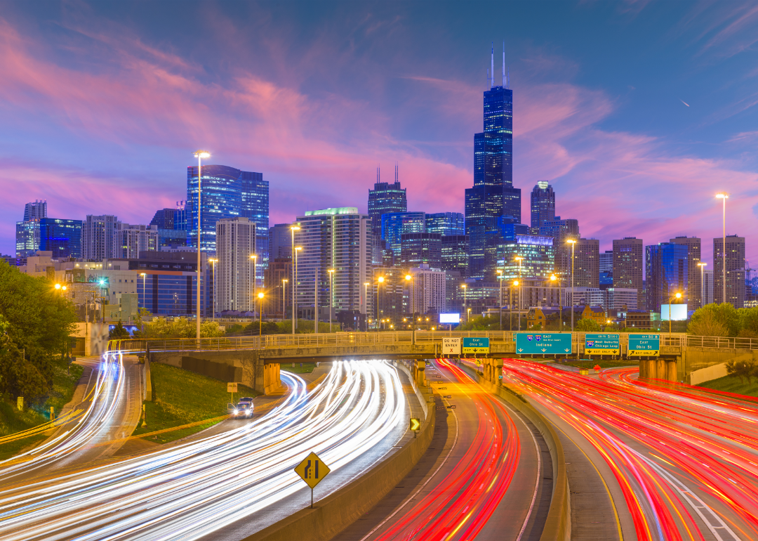
#44. Illinois
- Miles driven per capita: 8,473
- Miles driven in rural areas: 23.8% (#40 among all states)
- Miles driven by road type:
--- Interstate: 32.1% (#4 among all states)
--- Freeway: 1.3% (#39)
--- Arterial: 40.5% (#24)
--- Collector: 12.4% (#35)
--- Local: 13.7% (#22)
Illinois is home to the nation’s third-largest city, with residents of Chicago and some three dozen surrounding suburbs able to take advantage of regional public transit through the six-county metropolitan area. The Chicago Transit Authority buses serve almost 11,000 stops, its rail cars serve 145 stations, and some service is around the clock.
#43. New Jersey
- Miles driven per capita: 8,704
- Miles driven in rural areas: 6.3% (#49 among all states)
- Miles driven by road type:
--- Interstate: 21.5% (#47 among all states)
--- Freeway: 17.5% (#2)
--- Arterial: 37.0% (#35)
--- Collector: 8.1% (#49)
--- Local: 15.9% (#16)
New Jersey might evoke images of souped-up cars and busy highways, but over 90,000 passengers typically ride NJ Transit into New York City on a typical workday, and that’s only a 10th of the passengers riding buses, trains, and light rail throughout the state each workday. Pennsylvania’s Port Authority Transit Corporation, Amtrak, and private bus lines stretch throughout the rest of the state.
#42. Oregon
- Miles driven per capita: 8,793
- Miles driven in rural areas: 39.6% (#24 among all states)
- Miles driven by road type:
--- Interstate: 26.7% (#21 among all states)
--- Freeway: 4.0% (#30)
--- Arterial: 44.0% (#7)
--- Collector: 14.5% (#23)
--- Local: 10.8% (#33)
Aimed at lowering driving rates, the state of Oregon offers programs and planning apps for residents to compare commuting routes, plan trips by transit, cycling, or walking, and join vanpools and carpools. The number of drivers traveling alone has been dropping in the Portland area in recent years, and a growing number of residents are walking, biking, and carpooling, research has shown.
#41. California
- Miles driven per capita: 8,818
- Miles driven in rural areas: 16.8% (#45 among all states)
- Miles driven by road type:
--- Interstate: 26.4% (#24 among all states)
--- Freeway: 19.5% (#1)
--- Arterial: 34.9% (#43)
--- Collector: 10.6% (#44)
--- Local: 8.7% (#44)
Los Angeles is often characterized by its tangled knot of jammed freeways, but the state overall does less driving than that portrayal suggests. Ride-hailing and ride-sharing took off in California, where Uber and Lyft alone account for more than a half-million drivers and millions of passengers. Policymakers have been trying to wean more Californians from driving with proposals to improve public transit like high-speed rail and build affordable housing developments around transit hubs. Research shows that gridlock costs California $29 billion each year in wasted time and fuel.
#40. Connecticut
- Miles driven per capita: 8,844
- Miles driven in rural areas: 10.0% (#48 among all states)
- Miles driven by road type:
--- Interstate: 32.9% (#3 among all states)
--- Freeway: 14.3% (#5)
--- Arterial: 31.0% (#49)
--- Collector: 12.1% (#38)
--- Local: 9.7% (#40)
Connecticut residents ride a lot of trains and buses instead of driving. The commuter rail into New York City on typical weekdays has a ridership of more than 126,000 trips, and the state has local and express buses and three rail lines of its own. In 2019, the state held a competition offering prizes to commuters for driving less. The contest resulted in more than 47,000 car trips eliminated and 785,000 fewer miles driven, according to state statistics.
#39. Arizona
- Miles driven per capita: 9,223
- Miles driven in rural areas: 24.7% (#38 among all states)
- Miles driven by road type:
--- Interstate: 22.1% (#43 among all states)
--- Freeway: 13.0% (#7)
--- Arterial: 42.6% (#10)
--- Collector: 10.3% (#46)
--- Local: 12.0% (#29)
One of every six residents of Arizona is 65 or older, and retirees tend to drive less than the general population. Driving rates in Arizona have dropped overall due to rising numbers of people working from home and the growing use of public transportation in urban Phoenix and urban Tucson.
#38. Nevada
- Miles driven per capita: 9,333
- Miles driven in rural areas: 20.1% (#42 among all states)
- Miles driven by road type:
--- Interstate: 25.1% (#28 among all states)
--- Freeway: 6.4% (#26)
--- Arterial: 37.0% (#34)
--- Collector: 9.8% (#48)
--- Local: 21.6% (#4)
Nearly one in five Nevada residents lives in Las Vegas, which is served by buses, taxis, and monorails. The city of Reno also has an extensive bus system, and the two cities are linked by Amtrak. Last year, the state started collecting drivers’ odometer readings during vehicle registration for lawmakers to use in making decisions on infrastructure funded by the state’s fuel tax. The data collection ran into opposition from critics who said it infringed on drivers’ freedoms.
#37. Colorado
- Miles driven per capita: 9,473
- Miles driven in rural areas: 29.5% (#33 among all states)
- Miles driven by road type:
--- Interstate: 27.2% (#19 among all states)
--- Freeway: 11.0% (#12)
--- Arterial: 41.6% (#15)
--- Collector: 10.3% (#45)
--- Local: 10.0% (#36)
Driving in Colorado is not easy and gets bad reviews. Residents say gas is pricey, roads could be in better shape, car theft is a problem, and rush-hour traffic jams are a plague. To top it off, the snow and icy conditions of winter driving are hazardous in the Rocky Mountain state.
#36. Massachusetts
- Miles driven per capita: 9,674
- Miles driven in rural areas: 4.6% (#50 among all states)
- Miles driven by road type:
--- Interstate: 27.4% (#18 among all states)
--- Freeway: 9.7% (#16)
--- Arterial: 42.0% (#12)
--- Collector: 8.0% (#50)
--- Local: 12.9% (#26)
Public transportation offers enough options to make driving in and to congested Boston unnecessary, with plenty of buses, subways, commuter trains, trolleys, and bikes to share. A driver in Boston loses an average of 53 hours a year—more than one hour a week—to congestion. In 1927, Massachusetts became the first state to insist upon proof of auto insurance for vehicle registration. It has one of the lowest rates of vehicular deaths.
#35. Ohio
- Miles driven per capita: 9,793
- Miles driven in rural areas: 30.3% (#32 among all states)
- Miles driven by road type:
--- Interstate: 30.1% (#9 among all states)
--- Freeway: 7.4% (#21)
--- Arterial: 31.7% (#48)
--- Collector: 17.2% (#8)
--- Local: 13.6% (#23)
Ohio is unique in having three large cities—Cincinnati, Cleveland, and Columbus—along with five midsized cities—Akron, Canton, Dayton, Toledo, and Youngstown. Three of every five residents live in one of these urban areas, which have public transportation alternatives to driving. The rest of the population is located in small towns and rural areas that lack regular public transit options, making them reliant on individual driving.
#34. Texas
- Miles driven per capita: 9,826
- Miles driven in rural areas: 27.2% (#36 among all states)
- Miles driven by road type:
--- Interstate: 25.3% (#27 among all states)
--- Freeway: 12.1% (#10)
--- Arterial: 40.5% (#23)
--- Collector: 15.6% (#16)
--- Local: 6.5% (#49)
Driving in Texas ranges from open roads of fast-moving cars to aggravating rush-hour traffic jams. The commutes in Fort Worth, Dallas, Houston, Austin, and San Antonio all average a half-hour. In Austin, 1.5% of residents commute to work by bicycle, while in Amarillo, nearly 16% carpool to their jobs. Insurance rates run about a third higher than the national average, due in part to high speed limits that can reach 85 mph, dense urban areas, and a high rate of fatal accidents.
#33. Maryland
- Miles driven per capita: 9,892
- Miles driven in rural areas: 17.8% (#43 among all states)
- Miles driven by road type:
--- Interstate: 30.0% (#10 among all states)
--- Freeway: 12.2% (#9)
--- Arterial: 37.0% (#33)
--- Collector: 12.5% (#34)
--- Local: 8.3% (#46)
Maryland is often cited as one of the worst states for driving. It has a reputation for having a high percentage of roads in bad condition, high insurance rates, a high car-theft rate, and some of the longest commutes in the country.
#32. Virginia
- Miles driven per capita: 10,019
- Miles driven in rural areas: 34.0% (#27 among all states)
- Miles driven by road type:
--- Interstate: 31.0% (#6 among all states)
--- Freeway: 7.1% (#25)
--- Arterial: 41.0% (#17)
--- Collector: 11.7% (#40)
--- Local: 9.3% (#42)
Driving in Virginia can mean breezing along scenic roads in the Blue Ridge Mountains or inching along a clogged highway into the nation’s capital. One in every 10 Virginians drives more than an hour to and from work. Two-thirds commute alone, but among the Virginia residents commuting into Washington D.C., the number driving alone drops to 41%.
#31. Idaho
- Miles driven per capita: 10,095
- Miles driven in rural areas: 57.5% (#10 among all states)
- Miles driven by road type:
--- Interstate: 25.3% (#26 among all states)
--- Freeway: 3.4% (#32)
--- Arterial: 40.4% (#25)
--- Collector: 13.1% (#31)
--- Local: 17.8% (#12)
Idahoans enjoy one of the lowest average rates for car insurance in the country. The average of $1,018 a year in the state is just two-thirds of the national average. Fueling the low rates are the state's low population density and its mostly rural roadways.
#30. Utah
- Miles driven per capita: 10,145
- Miles driven in rural areas: 27.8% (#35 among all states)
- Miles driven by road type:
--- Interstate: 36.6% (#1 among all states)
--- Freeway: 1.7% (#38)
--- Arterial: 35.1% (#40)
--- Collector: 11.0% (#43)
--- Local: 15.6% (#18)
For drivers, the scenic roads of Utah are among the safest. The state has among the fewest number of drunk-driving cases in the country and has strict laws on securing children up to age 8 in car seats or booster seats. However, the state does allow speeds of 80 mph on its interstates.
#29. New Hampshire
- Miles driven per capita: 10,156
- Miles driven in rural areas: 39.8% (#23 among all states)
- Miles driven by road type:
--- Interstate: 22.6% (#38 among all states)
--- Freeway: 11.4% (#11)
--- Arterial: 38.8% (#29)
--- Collector: 18.4% (#6)
--- Local: 8.8% (#43)
Driving in New Hampshire means never having to wear a seat belt. The state is the only one in the country that does not mandate seat belt use, although children must wear them. New Hampshire has one of the lowest average rates for annual auto insurance, at about $985 a year. It’s one of just two states (the other being Virginia), that does not require drivers to buy auto insurance. Instead, state law requires drivers to prove they have sufficient funds to address potential financial responsibilities, or else lose their license.
#28. Michigan
- Miles driven per capita: 10,244
- Miles driven in rural areas: 30.5% (#31 among all states)
- Miles driven by road type:
--- Interstate: 23.1% (#34 among all states)
--- Freeway: 9.1% (#18)
--- Arterial: 44.0% (#6)
--- Collector: 14.1% (#24)
--- Local: 9.7% (#41)
Driving as a Michigan resident means paying the highest auto insurance rates in the country. The average premium of $2,878 is 90% higher than the national average. Driving the cost is a no-fault insurance plan that requires all drivers to carry personal injury protection coverage to help cover medical costs linked to an accident. Other states have the same system, but Michgan’s guarantees unlimited lifetime benefits to victims, which can get very expensive.
#27. Florida
- Miles driven per capita: 10,414
- Miles driven in rural areas: 16.6% (#46 among all states)
- Miles driven by road type:
--- Interstate: 18.7% (#49 among all states)
--- Freeway: 8.0% (#19)
--- Arterial: 39.6% (#26)
--- Collector: 13.3% (#28)
--- Local: 20.3% (#9)
Florida drivers pay insurance rates that are higher by an average of nearly 50% more than in most other states. The state has a high population of drivers who are considered high-risk and drive up premiums: seniors, tourists, and students. Also, driving in the state means worrying about increasingly severe storms like tornadoes and hurricanes.
#26. Delaware
- Miles driven per capita: 10,525
- Miles driven in rural areas: 24.3% (#39 among all states)
- Miles driven by road type:
--- Interstate: 14.6% (#50 among all states)
--- Freeway: 10.3% (#15)
--- Arterial: 44.2% (#4)
--- Collector: 16.5% (#11)
--- Local: 14.4% (#20)
Delaware is studying the feasibility of taxing drivers on how far they drive rather than through fuel taxes. Fuel-tax revenues have dropped as cars have become more efficient. The federally funded study was slated to end next year with a feasibility report on mileage-based revenues.
#25. Iowa
- Miles driven per capita: 10,545
- Miles driven in rural areas: 59.2% (#8 among all states)
- Miles driven by road type:
--- Interstate: 25.0% (#29 among all states)
--- Freeway: 0.0% (#47)
--- Arterial: 48.8% (#1)
--- Collector: 16.3% (#14)
--- Local: 9.9% (#37)
Iowa is one of the safest states in the country for driving and among the least expensive, as well. The state has among the fewest cases of careless driving, and not wearing a seat belt can mean a hefty fine.
#24. Louisiana
- Miles driven per capita: 10,739
- Miles driven in rural areas: 39.0% (#25 among all states)
- Miles driven by road type:
--- Interstate: 33.1% (#2 among all states)
--- Freeway: 2.0% (#36)
--- Arterial: 42.2% (#11)
--- Collector: 15.1% (#20)
--- Local: 7.6% (#48)
Driving along Louisiana’s delta, bayous, and Mississippi River shorelines can be perilous. The state ranks near the bottom in cases of failure to obey and careless driving, drunk driving, distracted driving, and speeding. It is one of the worst states for fatal crashes with a driver who does not have a valid license. Not unrelated, Louisiana has some of the highest auto insurance rates, more than 50% above the national average.
#23. West Virginia
- Miles driven per capita: 10,769
- Miles driven in rural areas: 50.7% (#13 among all states)
- Miles driven by road type:
--- Interstate: 31.3% (#5 among all states)
--- Freeway: 0.5% (#44)
--- Arterial: 40.6% (#21)
--- Collector: 19.1% (#5)
--- Local: 8.6% (#45)
Drivers in West Virginia must navigate narrow winding roads, steep hills, and tight curves through the state’s storied hollows and mountains. Frequent hazardous weather like thunderstorms and flash flooding add to the driving risks. Three of every five casualties in car accidents occur in the state’s rural areas.
#22. Minnesota
- Miles driven per capita: 10,771
- Miles driven in rural areas: 40.8% (#21 among all states)
- Miles driven by road type:
--- Interstate: 21.8% (#46 among all states)
--- Freeway: 7.8% (#20)
--- Arterial: 43.2% (#9)
--- Collector: 14.8% (#22)
--- Local: 12.3% (#28)
Minnesota ranks high in terms of having the fewest cases of careless driving in the country, and the number of vehicle-related pedestrian and bicycle deaths is low. Compared to other states, Minnesota requires drivers to carry significantly high levels of bodily injury and property damage liability insurance, personal injury protection, and uninsured and underinsured motorist coverage.
#21. Nebraska
- Miles driven per capita: 10,872
- Miles driven in rural areas: 55.4% (#11 among all states)
- Miles driven by road type:
--- Interstate: 22.2% (#42 among all states)
--- Freeway: 10.7% (#13)
--- Arterial: 44.1% (#5)
--- Collector: 11.4% (#41)
--- Local: 11.6% (#31)
Cities and towns are closer together at the eastern end of Nebraska, where Omaha and Lincoln are located. To the west, towns are far apart and the roads are wide open amid prairie, agricultural fields, and ranches. Pick-up trucks sell at twice the average rate of the rest of the country. But more than half of the state's major roads are not in good condition, and seat belt use is lower than in many other states, in part because Nebraska does not have a primary seat belt law that would allow police to stop drivers specifically over their use.
#20. South Dakota
- Miles driven per capita: 11,016
- Miles driven in rural areas: 69.8% (#4 among all states)
- Miles driven by road type:
--- Interstate: 29.5% (#11 among all states)
--- Freeway: 5.3% (#27)
--- Arterial: 41.9% (#13)
--- Collector: 15.6% (#17)
--- Local: 7.6% (#47)
South Dakota gets low marks for driving safety. More than half of the fatal vehicle crashes involve victims not wearing seat belts, research has found, and motorcyclists are not required to wear helmets. Nine out of 10 traffic deaths occur on South Dakota’s many rural roads. Drivers can get learner’s permits at age 14 and full licenses at age 16 in South Dakota, as in other farming states like North Dakota and Iowa.
#19. Maine
- Miles driven per capita: 11,046
- Miles driven in rural areas: 68.8% (#6 among all states)
- Miles driven by road type:
--- Interstate: 23.0% (#36 among all states)
--- Freeway: 1.0% (#41)
--- Arterial: 35.5% (#39)
--- Collector: 27.7% (#1)
--- Local: 12.8% (#27)
Auto insurance in Maine runs about 40% cheaper than the national average, thanks largely to its low population density. The state also has the lowest number of uninsured drivers in the country, a factor that pushes rates lower. Collisions with moose have always been a hazard in Maine, although the rate has dropped in recent years as the moose herd has gotten smaller. Moose are massive creatures, and such collisions are far more likely to end in human death than are collisions with deer.
#18. Kansas
- Miles driven per capita: 11,056
- Miles driven in rural areas: 47.7% (#17 among all states)
- Miles driven by road type:
--- Interstate: 24.7% (#31 among all states)
--- Freeway: 10.5% (#14)
--- Arterial: 34.7% (#44)
--- Collector: 16.8% (#10)
--- Local: 13.3% (#24)
One indication of how very rural Kansas driving is can be found in its state driving exam, which does not require applicants to know how to parallel park. Outside of Topeka and Wichita in the eastern half of the state, roads in Kansas are mostly straight and flat. In addition, Interstate 70 runs the length of the state. A pending lawsuit by the American Civil Liberties Union and others claims the Kansas Highway Patrol targets out-of-state drivers and that 93% of traffic stops made in 2017 involved vehicles with out-of-state license plates.
#17. Kentucky
- Miles driven per capita: 11,088
- Miles driven in rural areas: 53.7% (#12 among all states)
- Miles driven by road type:
--- Interstate: 30.7% (#7 among all states)
--- Freeway: 4.8% (#28)
--- Arterial: 35.1% (#42)
--- Collector: 18.3% (#7)
--- Local: 11.2% (#32)
Largely rural, Kentucky has one of the nation’s highest vehicle-related fatality rates. It ranks among the five U.S. states with the most distracted drivers, according to the National Highway Traffic Safety Administration. In practice, distracted driving means that a driver going 65 mph who looks away from the road for three seconds has traveled the length of a U.S. football field. Unlike many states, Kentucky does not impose any restrictions on older drivers such as road tests or more frequent license renewal.
#16. South Carolina
- Miles driven per capita: 11,172
- Miles driven in rural areas: 45.1% (#18 among all states)
- Miles driven by road type:
--- Interstate: 28.5% (#14 among all states)
--- Freeway: 1.9% (#37)
--- Arterial: 43.4% (#8)
--- Collector: 16.5% (#12)
--- Local: 9.8% (#39)
Communities in South Carolina are largely spread out, and many regions have very limited bus service, leaving residents reliant on their cars. But South Carolina has the highest rate of drunk driving incidents of any state. Nearly a third of its traffic deaths are alcohol-related. In recent years, South Carolina frequently has had the most traffic-related deaths in the country.
#15. Wisconsin
- Miles driven per capita: 11,333
- Miles driven in rural areas: 50.6% (#14 among all states)
- Miles driven by road type:
--- Interstate: 22.0% (#44 among all states)
--- Freeway: 7.2% (#23)
--- Arterial: 40.5% (#22)
--- Collector: 19.8% (#4)
--- Local: 10.5% (#34)
More than half of the major roads in Wisconsin were found to be in poor condition, according to a nonprofit research report released in 2018. It found that the average driver in Madison and Milwaukee spends nearly $1,000 a year on repairs and maintenance linked to the quality of the roads. The report blamed the poor conditions on inadequate state and local funding. On the bright side, Wisconcin’s auto insurance rates are comparatively cheap, kept in check by the extent of its rural areas in which there are lower rates of claims and accidents.
#14. Oklahoma
- Miles driven per capita: 11,522
- Miles driven in rural areas: 48.6% (#15 among all states)
- Miles driven by road type:
--- Interstate: 24.6% (#32 among all states)
--- Freeway: 7.1% (#24)
--- Arterial: 41.9% (#14)
--- Collector: 16.4% (#13)
--- Local: 10.0% (#35)
Driving distances are long and roads are straight in Oklahoma. In fact, one of the longest stretches of straight road in the country, U.S. Route 54, slices diagonally more than 60 miles through the Oklahoma panhandle from Texhoma to the Kansas border. From centrally located Oklahoma City, other major cities are Dallas, three hours away, and Kansas City, a five-hour drive.
#13. North Carolina
- Miles driven per capita: 11,665
- Miles driven in rural areas: 34.0% (#28 among all states)
- Miles driven by road type:
--- Interstate: 22.4% (#39 among all states)
--- Freeway: 7.4% (#22)
--- Arterial: 35.1% (#41)
--- Collector: 15.0% (#21)
--- Local: 20.1% (#10)
North Carolina offers idyllic, scenic drives on the Blue Ridge Parkway, through the Pisgah National Forest, and along the Cape Fear River and the Outer Banks. But drivers in Charlotte lose nearly an hour a week to traffic congestion. Also, a study released in July 2020 by the state’s Criminal Justice Analysis Center in showed that Black drivers are stopped by law enforcement officers twice as often as white drivers. There were 1.25 million traffic stops in North Carolina last year.
#12. Vermont
- Miles driven per capita: 11,729
- Miles driven in rural areas: 71.0% (#1 among all states)
- Miles driven by road type:
--- Interstate: 24.8% (#30 among all states)
--- Freeway: 0.9% (#42)
--- Arterial: 36.0% (#37)
--- Collector: 21.6% (#3)
--- Local: 16.7% (#14)
Pastoral Vermont is one of the 10 safest states for driving, as calculated by deaths per miles driven. It also can boast of having the fewest number of car thefts per capita. Vermont’s Route 7 runs the length of the state through picturesque small towns and farmland for about 175 miles, stretching from the New York state border north to Canada.
#11. Montana
- Miles driven per capita: 11,955
- Miles driven in rural areas: 68.9% (#5 among all states)
- Miles driven by road type:
--- Interstate: 25.7% (#25 among all states)
--- Freeway: 0.0% (#47)
--- Arterial: 44.3% (#3)
--- Collector: 13.5% (#27)
--- Local: 16.5% (#15)
Montana's roads, with their alluring names like Beartooth Highway and Going-to-the-Sun Road, course through alpine tundra, glacial lakes, wild rivers, and high plains. But drives in Montana can be risky. Montana has the most deaths involving single-vehicle crashes of any state and also is estimated to have the most drivers killed who had blood-alcohol content of 0.08%—the widely recognized level that indicates impairment—or higher. In terms of deaths per 100 million vehicle miles traveled, Montana is among the 10 most dangerous states in the nation.
#10. Tennessee
- Miles driven per capita: 12,012
- Miles driven in rural areas: 31.8% (#30 among all states)
- Miles driven by road type:
--- Interstate: 29.5% (#12 among all states)
--- Freeway: 3.2% (#33)
--- Arterial: 39.4% (#27)
--- Collector: 12.7% (#32)
--- Local: 15.2% (#19)
Every county in Tennessee has some form of public transportation, from express buses to local shuttles, but the state ranks in the top 10 states with the most miles driven per capita. Interstate 40 runs the length of the state, linking Memphis in the west and traveling through Nashville and Knoxville to the North Carolina line. Some of the prettiest roads in Tennessee are Natchez Trace, which follows an ancient American Indian trail, the historic Antebellum Trail, and routes through the Cherokee National Forest and Great Smoky Mountains National Park.
#9. Arkansas
- Miles driven per capita: 12,169
- Miles driven in rural areas: 48.5% (#16 among all states)
- Miles driven by road type:
--- Interstate: 26.7% (#22 among all states)
--- Freeway: 3.6% (#31)
--- Arterial: 40.7% (#20)
--- Collector: 17.2% (#9)
--- Local: 11.9% (#30)
Arkansas ranks as the worst in the country for driving in the rain, with more crashes linked to wet weather than any other state. Spring is rainy in Arkansas, especially in the Ozark and Ouachita Mountains in the northwest. Overall, crashes in the rain are almost five times more common and more deadly than accidents in snow. Also, teens as young as 14 years old can get a driving learner’s permit in the rural state.
#8. Indiana
- Miles driven per capita: 12,183
- Miles driven in rural areas: 36.4% (#26 among all states)
- Miles driven by road type:
--- Interstate: 23.0% (#35 among all states)
--- Freeway: 2.9% (#34)
--- Arterial: 34.5% (#45)
--- Collector: 15.3% (#18)
--- Local: 24.3% (#3)
Highways radiate from centrally located Indianapolis like spokes on a wheel, making driving convenient. Traffic permitting, major cities like Fort Wayne, Gary, and Bloomington all are within a couple hours’ drive. But a study by the trucking industry found that three of the country’s worst bottlenecks are located in the highway interchanges around the state capital.
#7. Georgia
- Miles driven per capita: 12,496
- Miles driven in rural areas: 25.0% (#37 among all states)
- Miles driven by road type:
--- Interstate: 24.4% (#33 among all states)
--- Freeway: 2.6% (#35)
--- Arterial: 39.2% (#28)
--- Collector: 12.6% (#33)
--- Local: 21.2% (#6)
Buses connect Georgia’s major cities, and the city of Atlanta has built an extensive rapid transit system, but Georgians take to their cars nonetheless. Rush-hour traffic on Atlanta’s downtown Connector—where Interstates 20, 75, and 85 meet—has the fifth-worst congestion in the country. Research shows a typical Atlanta driver spends 82 hours a year sitting in rush-hour congestion, 64 of those hours on the renowned Connector.
#6. Missouri
- Miles driven per capita: 12,502
- Miles driven in rural areas: 43.3% (#19 among all states)
- Miles driven by road type:
--- Interstate: 27.9% (#16 among all states)
--- Freeway: 13.9% (#6)
--- Arterial: 25.0% (#50)
--- Collector: 12.1% (#36)
--- Local: 21.0% (#8)
Interstate 70 cuts straight across Missouri, linking St. Louis and Kansas City in a drive of less than four hours. But Missouri is one of the most dangerous states for teen drivers, according to the National Highway Traffic Safety Administration. Teenage drivers in Missouri are more likely to text and drive and not wear a seat belt than teens nationwide, and the state's teen traffic fatality rate is about 90% worse than the national average.
#5. North Dakota
- Miles driven per capita: 12,967
- Miles driven in rural areas: 69.8% (#3 among all states)
- Miles driven by road type:
--- Interstate: 22.6% (#37 among all states)
--- Freeway: 0.0% (#47)
--- Arterial: 46.5% (#2)
--- Collector: 14.0% (#26)
--- Local: 16.8% (#13)
Driving in North Dakota is safe, fast, and inexpensive. It is among the top 10 states with the fewest car thefts, it has a low vehicular fatality rate, and gas prices, maintenance and repair prices are low. Car insurance is among the least costly, with the average annual premium priced at about a third less than the national average. To top it off, the average commute takes about 17 minutes, shaving 10 minutes off the national average.
#4. New Mexico
- Miles driven per capita: 13,023
- Miles driven in rural areas: 59.3% (#7 among all states)
- Miles driven by road type:
--- Interstate: 27.0% (#20 among all states)
--- Freeway: 0.4% (#45)
--- Arterial: 41.0% (#16)
--- Collector: 12.1% (#37)
--- Local: 19.5% (#11)
New Mexico offers scenic routes through its mountains, deserts, and ancient Native American lands. However, the state has one of the worst safety records in the country. More than two-thirds of its traffic deaths are linked to speeding and drunk driving.
#3. Mississippi
- Miles driven per capita: 13,638
- Miles driven in rural areas: 58.5% (#9 among all states)
- Miles driven by road type:
--- Interstate: 21.8% (#45 among all states)
--- Freeway: 1.2% (#40)
--- Arterial: 40.7% (#19)
--- Collector: 15.1% (#19)
--- Local: 21.1% (#7)
Conducive to driving in Mississippi are the lowest gas prices in the country. The state has the least amount of congestion at rush hour as well. But only about three-quarters of the state’s drivers are insured, and it has one of the nation’s highest vehicle fatality rates.
#2. Alabama
- Miles driven per capita: 14,560
- Miles driven in rural areas: 40.5% (#22 among all states)
- Miles driven by road type:
--- Interstate: 22.2% (#41 among all states)
--- Freeway: 0.8% (#43)
--- Arterial: 38.2% (#30)
--- Collector: 14.1% (#25)
--- Local: 24.7% (#2)
Only four out of five Alabama drivers are insured, and the vehicle fatality rate is among the nation’s highest. It also ranks high in terms of speeding, traffic tickets, and other driving offenses. The state is among the worst for drunk driving, which is linked to more than a quarter of its traffic deaths.
#1. Wyoming
- Miles driven per capita: 18,067
- Miles driven in rural areas: 70.8% (#2 among all states)
- Miles driven by road type:
--- Interstate: 30.5% (#8 among all states)
--- Freeway: 0.1% (#46)
--- Arterial: 33.6% (#47)
--- Collector: 21.8% (#2)
--- Local: 14.0% (#21)
Cities and towns are remote and far apart in Wyoming. The state has no passenger train system, and buses follow highway routes to major destinations, so driving is a necessity. Per capita, Wyoming residents drive almost three times as many miles in an average year than do residents of New York.