Major cities most at risk of rising sea levels
Major cities most at risk of rising sea levels
Climate Action Tracker, an independent scientific analysis group, ranks America's policies as "critically insufficient" in keeping the rise of global temperatures under 2 degrees Celsius. That threshold is widely believed by the scientific community to be the tipping point for irreversible global calamities such as massive water and food shortages, catastrophic sea-level rise, and devastating spikes in disease—not to mention widespread extinctions and increased storm strengths. Despite this, the Trump administration continues to rescind federal climate policies and waive the urgency of global warming, while the Democratic National Committee (DNC) neglected to schedule a single climate-change debate for 2020 Democratic presidential candidates. Cable networks CNN and MSNBC scheduled climate forums and town halls for those candidates on Sept. 4 and 19-20, respectively.
Of course, planetary shifts don't wait for administrative reform. A warming atmosphere and rising sea levels are already affecting extreme weather across America, from 2019's extreme summer heat waves to California forest fires to the intense flooding Hurricane Sandy wrought on New York and New Jersey. Sandy, in particular, was a landmark event: the 2012 storm caused more than 150 deaths and an estimated $72 billion in economic damages. Scientists predict that massive floods like those caused by Sandy will become commonplace in the next few decades, as rising sea levels exacerbate storms and high tides.
To explore the places and people most at risk from higher seas, Stacker used data from Climate Central Coastal Flooding Report to rank the 30 major U.S. cities (with populations over 100,000) that will have the greatest number of residents in flood-prone areas by 2050. Based on the populations for each city determined in the 2010 U.S. Census, Climate Central researchers calculated the number of people out of those current populations living in 100-year floodplains defined by the Federal Emergency Management Agency (FEMA), as well as who will be living in those floodplains in 2050. The future projections are based on published sea-level rise projections and assume that carbon emissions will continue unrestricted (a scenario called Representative Concentration Pathway 8.5). FEMA defines a 100-year floodplain as an area with a 1% annual chance of flooding.
Although Climate Central analyzed cities across the country, Florida sticks out as a flood-prone state. Out of the 30 cities on this list, 13 are in the Sunshine State, and eight of those cities rank in the top 10. Read on to find out which cities might be underwater within a few decades, and what those cities' local leaders are (or aren't) doing to address the risk.
You may also like: 25 terms you should know to understand the climate change conversation
#30. Stamford, CT
- Population in 100-year flood zones by 2050: 7,260 (5.9% of current population)
- Population currently in 100-year flood zones: 1,692 (1.4% of current population; rank #28)
- Change in population exposed, 2015 to 2050: 5,568 (329.1% increase; rank #4)
- Current population (2010): 122,626
Since the city was first settled in the 17th century, Stamford has faced flooding from Long Island Sound. Although the U.S. Army Corps constructed a hurricane protection barrier system around the harbor in the 1960s, the city is still at risk from heavy storms. Thirty-two students in 2018 had to be rescued from a stuck public school bus after torrential rain caused the streets to flood.
#29. Bridgeport, CT
- Population in 100-year flood zones by 2050: 7,424 (5.1% of current population)
- Population currently in 100-year flood zones: 2,064 (1.4% of current population; rank #27)
- Change in population exposed, 2015 to 2050: 5,360 (259.7% increase; rank #5)
- Current population (2010): 144,229
Connecticut’s largest city is a historic seaport. It sits at the mouth of the Pequonnock River on Long Island Sound. In 2011, Hurricane Irene caused power outages and flooding across the city, with the storm surge entering and rising at a speed that one witness compared to a tsunami. City officials faced criticism from Bridgeport residents for failing to respond as storms have racked up millions in damages.
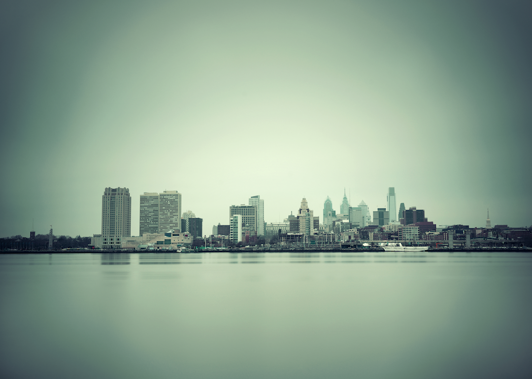
#28. Philadelphia, PA
- Population in 100-year flood zones by 2050: 8,457 (0.6% of current population)
- Population currently in 100-year flood zones: 5,335 (0.3% of current population; rank #24)
- Change in population exposed, 2015 to 2050: 3,122 (58.5% increase; rank #14)
- Current population (2010): 1.5 million
Although Philadelphia is located further inland than many other metros on this list, its proximity to the Delaware River puts Pennsylvania’s largest city at risk from storm surges and rising tide levels. One large July 2019 storm caused flooding across the city and forecasted trials to come, according to David Murrell of Philadelphia Magazine. Murrell noted that, while the current record for high-tide flood days in Philly is 12, NOAA estimates that the figure could rise to 30 in 2030 and more than 100 by 2050.
#27. Newport News, VA
- Population in 100-year flood zones by 2050: 11,375 (6.3% of current population)
- Population currently in 100-year flood zones: 5,204 (2.9% of current population; rank #25)
- Change in population exposed, 2015 to 2050: 6,171 (118.6% increase; rank #10)
- Current population (2010): 180,659
Newport News (not to be confused with the similarly named city in Rhode Island) is located on a peninsula, with the James River on one side and the Chesapeake Bay on the other. The city faces about $375,000 in annual flood damage, according to local news outlet the Daily Press. While officials and civil engineers in Newport News are more focused on the overall Hampton Roads region (which also includes Norfolk and Hampton, both of which have more low-lying areas), the city has implemented some flood protection measures, including water-level sensors and improved storm-water drainage.
#26. Mobile, AL
- Population in 100-year flood zones by 2050: 12,420 (6.4% of current population)
- Population currently in 100-year flood zones: 9,987 (5.1% of current population; rank #22)
- Change in population exposed, 2015 to 2050: 2,433 (24.4% increase; rank #21)
- Current population (2010): 195,111
Located along the hurricane-friendly Gulf of Mexico, Mobile is Alabama's third-largest city. The Federal Emergency Management Agency (FEMA) in 2017 updated flood maps for Mobile and Baldwin counties, extending flood zones in the city to include more than 10,000 more properties. City officials are using these maps to help more residents get flood insurance.
#25. Clearwater, FL
- Population in 100-year flood zones by 2050: 13,995 (13.0% of current population)
- Population currently in 100-year flood zones: 13,661 (12.7% of current population; rank #21)
- Change in population exposed, 2015 to 2050: 334 (2.4% increase; rank #30)
- Current population (2010): 107,685
Clearwater is one of the largest cities along Florida’s “Nature Coast,” an unofficial name for the state’s eight counties along the Gulf of Mexico. The city has seen its fair share of flooding already: In the summer of 2012, Tropical Storm Debby flooded coastal areas to the point that Clearwater Beach was “basically underwater.” FEMA updated flood zones for Pinellas County, where Clearwater is located, in June 2018.
#24. Savannah, GA
- Population in 100-year flood zones by 2050: 14,954 (11.0% of current population)
- Population currently in 100-year flood zones: 6,590 (4.8% of current population; rank #23)
- Change in population exposed, 2015 to 2050: 8,364 (126.9% increase; rank #9)
- Current population (2010): 136,286
Savannah faced a slew of storms in the last decade, including Hurricane Matthew in 2016 and Hurricane Irma in 2017. After Hurricane Matthew, John D. Sutter of CNN wrote that the storm “looks a lot like the future of climate change.” While there was not sufficient data to conclusively name Matthew a consequence of a warming planet, tropical hurricanes are expected to become more intense and frequent by 2100.
#23. Newark, NJ
- Population in 100-year flood zones by 2050: 15,559 (5.6% of current population)
- Population currently in 100-year flood zones: 1,593 (0.6% of current population; rank #29)
- Change in population exposed, 2015 to 2050: 13,966 (876.7% increase; rank #3)
- Current population (2010): 277,140
Hurricane Sandy hit New Jersey so severely in fall 2012 that “Effects of Hurricane Sandy in New Jersey” merited a separate Wikipedia page with almost 100 sources. In Newark, the storm caused mass flight delays, train shutdowns, power outages, and sewage overflow into the Passaic River. While the local government has helped residents recover from Sandy, researchers warn that New Jersey may not be ready for future flooding.
#22. Corpus Christi, TX
- Population in 100-year flood zones by 2050: 19,647 (6.4% of current population)
- Population currently in 100-year flood zones: 15,784 (5.2% of current population; rank #20)
- Change in population exposed, 2015 to 2050: 3,863 (24.5% increase; rank #20)
- Current population (2010): 305,184
North Beach, a popular tourist location on the north side of the Corpus Christi bridge, is also a popular spot for floodwaters. The streets in this area are barely above sea level, and the beach floods quickly during storms. During summer 2019, team of public officials and other stakeholders proposed a 1.2-mile canal that could redirect runoff and make North Beach safer. However, many investigations and debates will be necessary before this public works project becomes a reality.
#21. Cambridge, MA
- Population in 100-year flood zones by 2050: 24,015 (22.8% of current population)
- Population currently in 100-year flood zones: 186 (0.2% of current population; rank #30)
- Change in population exposed, 2015 to 2050: 23,829 (12,811.3% increase; rank #1)
- Current population (2010): 105,162
How many engineers does it take to save Cambridge from flooding? Nearby Boston has seen record flooding in recent years, due to heavy rain in the summer and heavy snow in the winter. Cambridge city officials are currently developing a "practical guide for climate change preparedness," and residents can use a flood viewer tool to learn about their potential risks.
#20. Chesapeake, VA
- Population in 100-year flood zones by 2050: 36,041 (16.3% of current population)
- Population currently in 100-year flood zones: 23,491 (10.6% of current population; rank #17)
- Change in population exposed, 2015 to 2050: 12,550 (53.4% increase; rank #15)
- Current population (2010): 221,576
Like their neighbors in Newport News, Chesapeake residents have to watch out for storm and tidal flooding from the nearby Chesapeake Bay. Since Chesapeake has more low-lying areas, this city currently faces more than $20 million in flood damage each year, more than 50 times the cost to Newport News. An intense rainstorm (five inches of rain in three hours) in June 2019 flooded Chesapeake streets in just 20 minutes.
#19. Hampton, VA
- Population in 100-year flood zones by 2050: 41,066 (29.9% of current population)
- Population currently in 100-year flood zones: 29,652 (21.6% of current population; rank #15)
- Change in population exposed, 2015 to 2050: 11,414 (38.5% increase; rank #17)
- Current population (2010): 137,373
Hampton, like other cities in the Hampton Roads region, has seen intense spikes in storm frequency and magnitude over the past decade. The city government works with the U.S. Geological Survey to monitor regional water levels at four locations: Newmarket Creek and Mercury Boulevard, The Hampton River at Route 351, Brick Kiln Creek at the NASA Langley Research Facility, and Sewells Point in Norfolk. The state government has also set up tiers of evacuation zones for residents to refer to and find their risk levels.
#18. Jersey City, NJ
- Population in 100-year flood zones by 2050: 42,541 (17.2% of current population)
- Population currently in 100-year flood zones: 31,472 (12.7% of current population; rank #14)
- Change in population exposed, 2015 to 2050: 11,069 (35.2% increase; rank #18)
- Current population (2010): 247,597
Cities along the Jersey Shore are three times more at risk than the national average, according to Climate Central’s research on real estate in the face of rising sea levels. Homes in high-risk areas on the state’s coast represent about $190 billion in property value, according to 2018 reporting in the Philly Voice. Jersey City Mayor Steven Fulop in 2017 joined a global pledge to reduce emissions locally.
#17. Jacksonville, FL
- Population in 100-year flood zones by 2050: 42,854 (5.2% of current population)
- Population currently in 100-year flood zones: 19,678 (2.4% of current population; rank #18)
- Change in population exposed, 2015 to 2050: 23,176 (117.8% increase; rank #11)
- Current population (2010): 819,050
Jacksonville is Florida’s largest city by population and the country’s largest by land area, coming in at 874.3 square miles—about three times the size of New York City. While much of the city lies in flood zones, it has room to expand in areas well above sea level, spurring Audrey Wachs of The Architect’s Newspaper to argue that this city could become a future “beacon of hope for a climate-ravaged state.” A special Jacksonville task force in 2019 conducted an audit on how to make the city more resilient in the face of flooding and rise in sea levels.
#16. Tampa, FL
- Population in 100-year flood zones by 2050: 57,131 (17.0% of current population)
- Population currently in 100-year flood zones: 49,551 (14.8% of current population; rank #12)
- Change in population exposed, 2015 to 2050: 7,580 (15.3% increase; rank #23)
- Current population (2010): 335,654
In 2017, the Washington Post reported that Tampa and the surrounding bay area is one of the most likely metro areas in the U.S. to be hit by a hurricane—and one of the least prepared. The local government there has repeatedly resisted acknowledging the role of climate change in warming temperatures and rising sea levels, even as local governments joined to investigate and adapt to the effects of climate change.
#15. Virginia Beach, VA
- Population in 100-year flood zones by 2050: 57,994 (13.3% of current population)
- Population currently in 100-year flood zones: 18,676 (4.3% of current population; rank #19)
- Change in population exposed, 2015 to 2050: 39,318 (210.5% increase; rank #6)
- Current population (2010): 436,497
Virginia Beach has long been a favored vacation spot for Americans along the East Coast, with a boardwalk that stretches for three miles along the Atlantic Ocean. Rising sea levels there threaten tourists and locals alike. The city in August 2019 authorized a $16 million study to investigate how Virginia Beach leaders should improve storm-water management, looking ahead to future flooding.
#14. Boston, MA
- Population in 100-year flood zones by 2050: 62,229 (10.1% of current population)
- Population currently in 100-year flood zones: 2,785 (0.5% of current population; rank #26)
- Change in population exposed, 2015 to 2050: 59,444 (2134.4% increase; rank #2)
- Current population (2010): 617,594
Boston’s local government is preparing to face future extreme events head-on through Climate Ready Boston, an ongoing local initiative to conduct research, boost the city’s infrastructure and increase the resiliency of Boston Harbor. Last fall, this initiative was lauded, as Boston was named the winner of the Bloomberg American Cities Climate Challenge.
#13. Cape Coral, FL
- Population in 100-year flood zones by 2050: 65,936 (42.9% of current population)
- Population currently in 100-year flood zones: 59,367 (38.6% of current population; rank #11)
- Change in population exposed, 2015 to 2050: 6,569 (11.1% increase; rank #25)
- Current population (2010): 153,809
Eugene Daniels in a 2017 Newsy story described Cape Coral as 400 miles of canals in a beachfront paradise: great for tourism, but terrible for hurricane preparation. The area is not eager to acknowledge climate change, so while climate resiliency audits have been conducted, the local government has not taken many steps to address its risk.
#12. Norfolk, VA
- Population in 100-year flood zones by 2050: 66,418 (27.4% of current population)
- Population currently in 100-year flood zones: 28,586 (11.8% of current population; rank #16)
- Change in population exposed, 2015 to 2050: 37,832 (132.3% increase; rank #8)
- Current population (2010): 242,751
Norfolk is built around Naval Station Norfolk, the largest naval base in the world. When the sea level rises there, it threatens 75 ships and 134 aircraft, which conduct one flight every six minutes. The city is testing a holistic plan that combines climate adaptation and economic development by fortifying existing neighborhoods and building developments away from flood-prone areas.
#11. Miami Gardens, FL
- Population in 100-year flood zones by 2050: 72,396 (67.6% of current population)
- Population currently in 100-year flood zones: 44,021 (41.1% of current population; rank #13)
- Change in population exposed, 2015 to 2050: 28,375 (64.5% increase; rank #13)
- Current population (2010): 107,167
Miami Gardens is a bit further inland than Miami itself, but like other cities across Florida, it still runs a high risk from tropical storms and tidal surges. This city has a few protections for residents, including a rule that, if a structure is significantly damaged or improved, it will need to be evaluated and potentially renovated to comply with floodplain requirements.
#10. Hollywood, FL
- Population in 100-year flood zones by 2050: 76,423 (54.6% of current population)
- Population currently in 100-year flood zones: 68,633 (49.0% of current population; rank #9)
- Change in population exposed, 2015 to 2050: 7,790 (11.4% increase; rank #24)
- Current population (2010): 139,946
Homes in Hollywood have already seen a severe loss in property values to the tune of $300 million between 2005 and 2017, according to a study from the nonprofit research group First Street Foundation. Activists in the city have embraced the Green New Deal as a model for local policies that can reduce emissions and prepare for future climate consequences, even as the congressional plan lost steam at the federal level.
#9. Charleston, SC
- Population in 100-year flood zones by 2050: 82,547 (68.9% of current population)
- Population currently in 100-year flood zones: 64,395 (53.7% of current population; rank #10)
- Change in population exposed, 2015 to 2050: 18,152 (28.2% increase; rank #19)
- Current population (2010): 119,875
Regular summer thunderstorms and high tide days already cause flooding in the historic parts of Charleston during hurricane season, and conditions are expected to only grow worse. In a 2018 article in The Post and Courier, Chloe Johnson outlined five significant consequences of climate change for the city’s residents: harsher hurricanes, dwindling habitats for oysters (an important local product), worse flooding, higher electric bills, and a lack of farm work and other outdoor jobs.
#8. St. Petersburg, FL
- Population in 100-year flood zones by 2050: 91,291 (37.3% of current population)
- Population currently in 100-year flood zones: 87,765 (35.9% of current population; rank #6)
- Change in population exposed, 2015 to 2050: 3,526 (4.0% increase; rank #27)
- Current population (2010): 244,767
St. Petersburg is close to Tampa (slide #16), on the coast of hurricane-bait region Tampa Bay. Kirby Wilson of the Tampa Bay Times reported that, under some federal projections, sea levels would rise by an average of eight feet by 2100—high enough to submerge the campus of Eckerd College along St. Petersburg’s southern coast. Tampa Bay’s local Regional Resiliency Coalition scheduled a climate summit in fall 2019 and hoped to approve a regional plan by March 2020. However, the group does not hold any regulatory power, so locals are skeptical about its capacity to impact change.
#7. Miramar, FL
- Population in 100-year flood zones by 2050: 99,863 (93.1% of current population)
- Population currently in 100-year flood zones: 92,572 (86.3% of current population; rank #5)
- Change in population exposed, 2015 to 2050: 7,291 (7.9% increase; rank #26)
- Current population (2010): 107,278
A South Florida city near Miami, Miramar is already highly susceptible to floods. The city takes part in the National Flood Insurance Program’s Community Rating System, a volunteer program that encourages community floodplain management activities. Wayne Messam, Miramar’s Democratic mayor, is running for president on a campaign that highlights climate change.
#6. Coral Springs, FL
- Population in 100-year flood zones by 2050: 119,475 (98.7% of current population)
- Population currently in 100-year flood zones: 114,926 (94.9% of current population; rank #4)
- Change in population exposed, 2015 to 2050: 4,549 (4.0% increase; rank #28)
- Current population (2010): 121,062
The South Florida city of Coral Springs is highly vulnerable to rising sea levels even though it is located slightly inland, with almost 95% of residents already living in flood zones. The Everglades, one of America's largest national parks, is basically in this city's backyard.
#5. Pembroke Pines, FL
- Population in 100-year flood zones by 2050: 120,442 (97.3% of current population)
- Population currently in 100-year flood zones: 116,165 (93.8% of current population; rank #3)
- Change in population exposed, 2015 to 2050: 4,277 (3.7% increase; rank #29)
- Current population (2010): 123,802
Pembroke Pines is a neighbor of Coral Springs, also nestled between Everglades National Park and the Atlantic Ocean. The South Florida Sun Sentinel’s editorial board called climate change “the defining issue of the century,” noting that, while the sea has risen only nine inches in the past century, it is predicted to rise two feet by 2060. Official flood safety measures outlined by the local government for Pembroke Pines residents include recommending citizens “do not walk through flowing water” and “look out for animals” in the event of a flood.
#4. Fort Lauderdale, FL
- Population in 100-year flood zones by 2050: 126,819 (76.6% of current population)
- Population currently in 100-year flood zones: 84,858 (51.3% of current population; rank #7)
- Change in population exposed, 2015 to 2050: 41,961 (49.4% increase; rank #16)
- Current population (2010): 165,521
In spring 2009, Fort Lauderdale hosted the first-ever Southeast Florida Climate Leadership Summit, bringing together local leaders to discuss challenges and coordinate responses to increasing coastal flooding. After the summit, a regional compact was formed, including Broward, Miami-Dade, Monroe, and Palm Beach counties. Fort Lauderdale itself has a plan for 2035 that puts climate change front and center, incorporating this issue into improvements for the city’s sea wall, beaches, drainage systems, bridges, roads, and homes.
#3. Miami, FL
- Population in 100-year flood zones by 2050: 153,879 (38.5% of current population)
- Population currently in 100-year flood zones: 125,885 (31.5% of current population; rank #2)
- Change in population exposed, 2015 to 2050: 27,994 (22.2% increase; rank #22)
- Current population (2010): 399,457
Miami is both second-largest city in Florida and the second-most at risk in terms of rising sea levels city in Florida. According to a report by the Union of Concerned Scientists, about 12,000 homes in the city will face chronic flooding by 2060—almost one-fifth of the total households in the state which face flooding. The city has allocated more than $400 million to make citywide upgrades to parks, housing, and drainage, with $192 million alone all for seawall improvements, drainage, and pumps. Residents voted to raise taxes to cover the cost.
#2. Hialeah, FL
- Population in 100-year flood zones by 2050: 204,047 (90.8% of current population)
- Population currently in 100-year flood zones: 76,387 (34.0% of current population; rank #8)
- Change in population exposed, 2015 to 2050: 127,660 (167.1% increase; rank #7)
- Current population (2010): 224,634
An August 2019 study by real estate site Clever ranked Hialeah in the top five cities most vulnerable to climate disaster. The city was also rated among the top five cities least ready for climate disaster. Like others in South Florida, this city faces danger from heat waves as well as coastal flooding. Hialeah artist Xavier Cortada highlighted what this flooding could look like in a 2015 art exhibit including panels and performance art.
#1. New York, NY
- Population in 100-year flood zones by 2050: 426,065 (5.2% of current population)
- Population currently in 100-year flood zones: 244,783 (3.0% of current population; rank #1)
- Change in population exposed, 2015 to 2050: 181,282 (74.1% increase; rank #12)
- Current population (2010): 8.2 million
As the only non-Florida city in the top five on this list, New York is a high flood risk location by sheer numbers. More than 400,000 New Yorkers will live in flood zones by 2050, more than double the comparable number of people in Hialeah. The city declared a climate emergency earlier this year, and already has climate-focused projects in place, including plans to lower greenhouse gas emissions, climate resiliency design guidelines, and a city-specific flood hazard mapper.