Largest wildfires of the decade
At least 15 people by Sept. 11 had been reported dead from the wildfires razing parts of California, Oregon, and Washington. More than 100 wildfires were counted as burning simultaneously across 12 Western states and had already burned almost 7,000 square miles, according to the National Interagency Fire Center.
While data from the National Interagency Fire Center (NIFC) show that the number of wildfires in the United States has gone down over the last 30 years, the number of acres burned annually has gone up. The most recently available wildfire statistics from the Federation of American Scientists (based on NIFC data) shows U.S. wildfire acreage to have increased from 3.6 million acres in 2014 to 8.8 million acres in 2018. The Ash Creek Fire of 2012 affected 249,562 acres of land, while the NW Oklahoma Complex fire of 2017 charred 779, 292 acres—making it the largest wildfire of the past decade in terms of acreage burned.
Wildfire activity in western American forests has increased in recent decades, a change widely believed by scientists to have been largely caused by changes in the climate. Another factor could be the federal policy of the past that focused exclusively and somewhat erroneously on suppressing fires to protect the timber. Many studies suggest that this policy could have led to fire exclusion in forests, which results in a higher density of vegetation and an understory of grass and bushes. The wildfires thus get the fuel they need to burn with more intensity. Thus, a combination of climatic changes and past management practices might have made the present wildfire events so much more widespread and immense.
Wildfires significantly impact nearby wildlife, ecosystems, communities, and businesses. In 2018, California suffered $400 billion in damage, according to AccuWeather. In 2017, the U.S. Forest Service spent $2.9 billion to douse flames around the country. Besides the immediate damage wildfires bring, they also leave behind wreckage that takes up immense resources, time, and money to recover.
A megafire was once considered to be one that burns more than 100,000 acres. However, Stacker's analysis of the data provided by the National Interagency Fire Center from 2010 to August 2020 reveals megafires have burned twice that size or more in terms of acres in the past decade.
The fires featured in this gallery are ranked by the number of acres affected, according to the National Interagency Fire Center. It's important to note that the National Interagency Fire Center relies on local sources, and there is no consistent definition of what an affected acre is.
Keep reading to learn more about the largest wildfires of the decade.
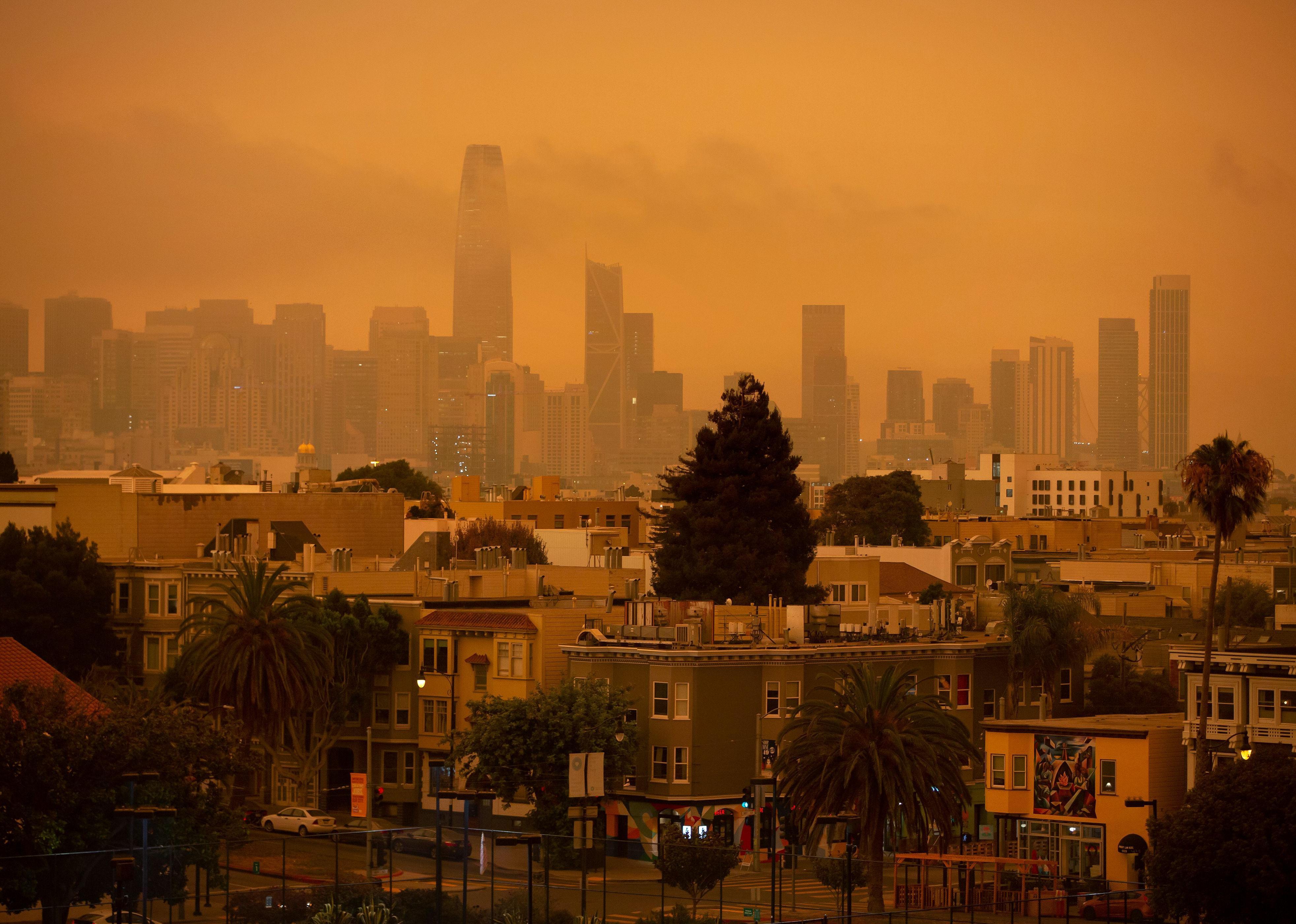
[Pictured: A hazy San Francisco skyline is seen from Dolores Park in San Francisco on Sept. 9, 2020. More than 300,000 acres are burning across the northwestern state including 35 major wildfires, with at least five towns "substantially destroyed" and mass evacuations taking place.]
You may also like: How climate change has affected each state
#25. Carlton Complex
- Year: 2014
- State most affected: Washington
- Acres affected: 256,108
East of the Methow River, near Carlton, four fires started because of a lightning storm on July 14, 2014. These fires soon converged as one and spread over the Methow Valley, creating the Carlton Complex Fire. Within a month, the megafire had destroyed over 250,000 acres of land and was still burning. By the time the fire was contained, it had already surpassed the record of the 1902 Yacolt Fire in terms of acres burned, and the fire destroyed 322 homes in the towns of Pateros and Brewster.
[Pictured: The Carlton Complex wildfire burning in north-central Washington, July 21, 2014.]
#24. Rim
- Year: 2013
- State most affected: California
- Acres affected: 257,314
The Rim Fire started on Aug. 17, 2013, in Stanislaus National Forest, west of Yosemite National Park in California, and it was contained by October. However, for the park staff, the aftermath of the fire was more worrisome. The burned land was prone to erosion as well as flooding, which could affect the water quality. The trees could be hazardous too if they fell on the nearby roads and rail lines.
While the forests were burning, the Rim Fire also threatened towns hundreds of miles away. According to the Sierra Nevada Conservancy group, air quality warnings were issued for Lake Tahoe, Carson City, and Reno, over 100 miles away. The governor of the city of San Francisco declared a state of emergency as the fire threatened the water and power resources of the city. It was the most massive fire in Sierra Nevada's history.
[Pictured: Morning briefing of fire crews is held at the Drew Meadow Incident Command Post on Aug. 17, 2013.]
#22. Thomas (tie)
- Year: 2017
- State most affected: California
- Acres affected: 270,000
The California Office of Emergency Services called the Thomas Fire "larger than every city in California, except Los Angeles." On Dec. 4, 2017, two power lines just above Ventura rubbed together, thus creating an electric arc that started a fire.
The fire proliferated between Ojai and Ventura, jumping Highway 150 and burning over 100,000 acres in just two days. The high winds caused the fire to move in great speed, but local experts from the forest and fire department sensed it was the thick brush that had not burned in decades that provided fuel even when the winds were down. It was officially contained on Jan. 12, 2018. The estimated loss was between $1 billion and $2.5 billion in Ventura and Santa Barbara.
[Pictured: The growing Thomas Fire advances toward Santa Barbara County seaside communities on Dec. 10, 2017, in Carpinteria, California.]
#22. Lodgepole Complex (tie)
- Year: 2017
- State most affected: Montana
- Acres affected: 270,000
The biggest wildfire of 2017 was the Lodgepole Complex Fire that was reported to have started in a remote area not known to many people out of the state. The group of four fires—Bridge Coulee, Barker, South Breaks, and Square Butte formed the Lodgepole Complex. It destroyed 16 homes or ranches while burning over a quarter-million acres.
Though the Fence Post reported that fewer cattle were lost to fires than was expected, the animals suffered from respiratory issues, and the most urgent need for ranchers was finding feed for their surviving livestock. Apart from the community, the fire also affected the core Sage Grouse habitat near Sand Springs.
[Pictured: Rice Ridge Fire in Montana on Sept. 13, 2017.]
You may also like: 30 incredible photos that show the true power of nature
#21. Sushgitit Hills
- Year: 2015
- State most affected: Alaska
- Acres affected: 270,747
During 2015, wild and prescribed fires burned a combined 5,150,673 acres in Alaska according to the 2015 Alaska Wildfire Emissions Inventory. This was much higher than previous records and was attributed mostly to climatic conditions such as dry spring and relatively fewer snowpacks. One of the 10 most significant fires in Alaska during this year was the Sushgitit Hills wildfire in an area where wildfires are usually allowed to burn.
[Pictured: The Alaska National Guard fights fires from above in June 2015.]
#20. Soda
- Year: 2015
- State most affected: Idaho
- Acres affected: 283,180
During the summer of 2015, the Soda Fire burned nearly 280,000 acres of sagebrush ecosystems just southwest of Boise, along the border of southern Idaho and eastern Oregon. This lightning-caused fire spread rapidly, affecting vegetation, wildlife, ranchers, and local communities. The most significant environmental impact of the blaze was the loss of habitat for sage grouse, bighorn sheep, mule deer, pronghorn, and golden eagles.
[Pictured: Soda Fire Emergency Wild Horse Gather Day 3, in Owyhee County on Aug. 28, 2015.]
#19. Rhea
- Year: 2018
- State most affected: Oklahoma
- Acres affected: 286,196
The Rhea Fire, located a half-mile west of Rhea, Oklahoma, began on April 12, 2018, and by April 20, 2018, the fire grew to over 280,000 acres. It was the third major fire in three back-to-back years that turned thousands of acres in the Oklahoma Plains to ashes. The Climate Signal website states that "these fires are three of the five worst fires on record in Oklahoma, going back to 1997," and the fires were fuelled by the rising temperature conditions, powerful winds, and very low relative humidity.
[Pictured: A thick wall of smoke from the Rhea wildfire engulfs a Dewey County road in western Oklahoma.]
#18. Whitewater- Baldy
- Year: 2012
- State most affected: New Mexico
- Acres affected: 297,845
The Whitewater–Baldy Complex Fire started on May 9, 2012, because of a lightning strike in Catron County. There were initially two separate fires that merged on May 23 and tore through the thick coniferous forests of the Gila National Forest with the help of strong winds. Grassland fires usually emit black smoke while forest fires emit white smoke, according to NASA. As the national forest had both types of vegetation, the smoke was thicker and both white and grey.
[Pictured: Whitewater-Baldy Complex Fire in the Gila National Forest on June 2, 2012.]
#17. Long Butte
- Year: 2010
- State most affected: Idaho
- Acres affected: 306,113
Between Aug. 21 and Aug. 29, 2010, the Long Butte Fire burned near Hagerman. On Aug. 23, approximately 215,000 acres of the 306,113 acres of the affected grassland was burned. The fire destroyed the home range of a wild horse herd and also charred three-fourths of the Hagerman Fossil Beds National Monument. It was the most massive fire of 2010.
[Pictured: Snake river from the Malad River overlook of U.S. 30 north of Hagerman, Idaho in October 2016.]
You may also like: Why does lightning strike? And answers to 50 other weather questions
#16. Old Grouch Top
- Year: 2019
- States most affected: Alaska
- Acres affected: 307,969
A lightning strike touched off the Old Grouch Top Fire on June 5, 2019, a few dozen miles northwest of McGrath, Alaska. The wildfire proceeded to burn 309,836 acres.
[Pictured: A helicopter passes by as smoke rises from a wildfire on July 3, 2019, south of Talkeetna, Alaska.]
#15. Honey Prairie
- Year: 2011
- State most affected: Georgia
- Acres affected: 309,200
The Honey Prairie fire started small due to a lightning strike but could not be contained for almost a year. It burned from April 30, 2011, to April 16, 2012, affecting 309,200 acres of land. The reason the fire was allowed to burn for such a long time was that it was burning scrub and brush in the Okefenokee Swamp in southern Georgia, meaning the land could revive with fresh prairie grass. The main intention of firefighters was, therefore, to keep structures safe rather than a total suppression of the fire.
[Pictured: 2011 Honey Prairie Fire at Okefenokee Swamp, Georgia.]
#14. Rock House
- Year: 2011
- State most affected: Texas
- Acres affected: 314,444
A house two miles west of the small town of Marfa caught fire on April 9, 2011. Soon, the flames began rising across Highway 90 and were burning pastures on the way. This was the beginning of the Rock House Fire that kept burning even after a month of containment efforts. Burning around the town of Fort Davis, the fire destroyed 26 homes and two businesses.
[Pictured: Rock House Fire in the Davis Mountains near Balmorhea in April 2011.]
#13. Rush
- Year: 2012
- State most affected: California
- Acres affected: 315,577
The Rush Fire started because of a lightning strike on Aug. 12, 2012. The fire was located 15 miles southeast of Ravendale and was burning at the same time as the Fort Complex Fire scorching the wilderness area shared with Oregon. In Nevada, the Rush Fire posed a risk of threatening a gas and power transmission lines. The fire also impacted the natural habitats of wild horses, burros, and grouse.
The estimated suppression cost was around $15 million for the fire, which was finally contained on Aug. 30, 2012.
[Pictured: Rush Fire in Lassen County, California on Aug. 30, 2012.]
#12. Perryton
- Year: 2017
- State most affected: Texas
- Acres affected: 318,156
The Perryton Fire became the third-largest fire in Texas history when it traveled to four counties scorching 318,156 acres. The Dumas Complex, Lefors East, and Perryton wildfires started as many small fires due to severe thunderstorms. The rainfall in the previous year had been high resulting in large quantities of fine fuel that helped spread the fire to vast regions aided by record high temperatures and strong winds. It proved disastrous for ranchers and landowners with the fire burning barns, outbuildings, and ranches and leading to the loss of livestock in hundreds.
[Pictured: The Texas National Guard fights wildfires threatening homes and property near Bastrop, Texas, on Sept. 6, 2011.]
#11. Mustang Complex
- Year: 2012
- State most affected: Idaho
- Acres affected: 341,448
A fire caused by lightning, the Mustang Complex Fire charred the rugged, steep, and inaccessible terrain near Salmon in July 2012. While the fire destroyed over 250,000 acres of the Salmon-Challis National Forest, firefighters could rescue a four-month-old orphaned black bear cub that had been found clinging to a fir tree with second-degree burns and blisters. The cub named Boo Boo was treated, his injuries bandaged, and in August 2012 was released back into the wild.
As per the NOAA National Centers for Environmental Information, the "estimated suppression costs for the Mustang Complex Fire exceeded $36 million through September."
[Pictured: A view of Mustang Complex Fires in Idaho from the International Space Station on Sept. 19, 2012.]
You may also like: Places with the most weather-related fatalities
#10. Anderson Creek
- Year: 2016
- State most affected: Oklahoma
- Acres affected: 367,740
The Anderson Creek Fire was described as the largest in Kansas history. It began in Oklahoma on March 22, 2016, and spread north to Kansas. The fire destroyed vital prairie and ranch land in three counties across the two states. Wildfire Today reported the loss of 600 cattle, 16 homes, 25 structures, and miles of fencing.
Ranchers like Mark Huddler, who lost 27 miles of fence and several buildings, however, found a silver lining among the disaster. While speaking to local news reporters, he said, "It's kind of the best of times coming out of the worst of times. We've got water in streams that haven't run for years because the fire decimated so many cedars."
[Pictured: Kansas National Guard Black Hawk helicopters join the fight against the Anderson Creek wildfire on March 26, 2016.]
#9. Buzzard Complex
- Year: 2014
- State most affected: Oregon
- Acres affected: 395,747
The Buzzard Complex Fires were ignited by lightning on July 13, 2014, at multiple locations east of the Stinkingwater Mountains in Harney County. The fire predominantly burned in the Vale District and was contained by Aug. 2, 2014. Oregon Live reported how the fire burned so hot and fast that 100-year-old junipers went up like Roman candles, a circular carpet of ash at their base.
The BLM Environment Assessment report later revealed that the progression of the fires was due in part to above-average fuel loading that sustained the fire even without the presence of high winds. The grass, too, was in plenty and tall enough to carry the fire.
[Pictured: A firefighter works to extinguish the Logging Unit fire west of Madras, Oregon, on July 21, 2014.]
#8. Ruby Area or Middle Yukon Fires
- Year: 2015
- State most affected: Alaska
- Acres affected: 421,613
The Ruby Area Fires was also known as the Middle Yukon Fires, as these were a series of fires mainly on the south side of the Yukon River near Ruby village. The fire included the Bruno Creek Fire, Trail Creek Fire, and the Big Creek Two Fire.
In a 2018 study published in the journal Carbon Balance and Management, researchers found that in the summer of 2015, more than 1.6 million hectares of boreal forest and wetlands in the Yukon-Koyukuk region had been destroyed. The research also found that there was a "65% reduction in soil carbon content and a 58% reduction in soil nitrogen content" in severely burned sites as compared to the unburnt sites.
[Pictured: The Alaska National Guard fights fires from the air on June 26, 2015.]
#7. Martin
- Year: 2018
- State most affected: Nevada
- Acres affected: 435,569
The Martin Fire erupted on July 5, 2018, near the Nevada town of Paradise Valley, most probably due to firecrackers or a campfire. By the next day, it had destroyed grazing areas, sage grouse habitat, and ranches. One reason the fire spread so fast, so soon was the invasive and highly inflammable cheatgrass that had been dominating the landscape, reports The Nevada Independent.
According to the National Interagency Fire Center's daily report, the Martin Fire's extreme growth had made it the largest fire burning the country at the time by a margin of hundreds and thousands of acres.
[Pictured: The Martin Fire as photographed by Sawtooth IHC on July 5, 2018.]
#6. Mendocino Complex
- Year: 2018
- State most affected: California
- Acres affected: 459,123
The Mendocino Complex Fire became the largest wildfire in California history when it was started accidentally by a homeowner trying to plug a wasp nest with a hammer and stake. This was actually the Ranch Fire, one of the two twin fires burning in the area at the same time. The other was the River Fire burning to the west of Clear Lake, the largest freshwater lake in the state. The fire destroyed 280 structures, including 157 homes and scorched an area bigger than Los Angeles, reports CNN.
[Pictured: Firefighters monitor a backfire as they battle the Mendocino Complex fire on Aug. 7, 2018, near Lodoga, California.]
You may also like: 15 ways to stay cool in the summer
#5. Holloway
- Year: 2012
- State most affected: Nevada
- Acres affected: 460,850
This fire was ignited by lightning on Aug. 5, 2012, near the Nevada-Oregon border. It burned private and public land and also the critical habitat of the Greater Sage-Grouse and the Lahontan Cutthroat trout, a federally listed threatened species. The fire burned thick sagebrush and grass along the steep slopes, making it challenging for firefighters to contain it in the difficult terrain.
[Pictured: A wildfire burns at night in northern Nevada.]
#4. Tanana Area Fires
- Year: 2015
- State most affected: Alaska
- Acres affected: 498,043
The Tanana Fire became one of the most damaging fires of 2015 when five large fires began burning near the village of Tanana in Alaska due to lightning strikes. The most ravaging was the Spicer Creek Fire that trapped the villagers between the blaze and the Yukon River. While most of the 300 residents began evacuating in June, some were rescued using boats as the airstrip was blanketed with smoke, according to news reports.
[Pictured: The Alaska National Guard surveys the scene while fighting wildfires on June 26, 2015.]
#3. Wallow
- Year: 2011
- State most affected: Arizona
- Acres affected: 538,049
The Wallow Fire was largest in Arizona history that burned in eastern Arizona and western New Mexico in 2011, mostly in the Apache-Sitgreave National Forest. It began accidentally when two people left a campfire unattended. The two were asked by the court to pay $3.7 million against claims for damage to private lands.
New reports reveal the fire cost government agencies $72 million to suppress and about $37 million more so far for assessment, clean up and rebuilding efforts.
[Pictured: A NASA satellite image shows smoke from the Wallow North fire in Arizona on June 6, 2011.]
#2. Long Draw
- Year: 2012
- State most affected: Oregon
- Acres affected: 557,628
Lightning strikes from a storm on July 8, 2012, started the Log Draw Fire and the Miller Homestead Fire at the same time. The Long Draw Fire primarily charred the Vale district burning private and public lands at historic levels because of conditions like low relative humidity at night, and heavy dry fuel loads. The fire destroyed livestock grazing areas, sage grouse habitats, and special areas, including wild horse herd management locations.
According to NOAA National Centers for Environmental Information, the Long Draw Fire was the largest fire to impact Oregon since the 1840s and surpassed 2002's Biscuit Fire in terms of acreage burned.
[Pictured: Oregon Fire Crew 7 waits for a local rancher to move his cattle into an area they protected from the Long Draw fire.]
#1. NW Oklahoma Complex
- Year: 2017
- State most affected: Oklahoma
- Acres affected: 779,292
A grass fire, which started burning in the Mocane oil field by County Road 141 in Beaver County because of a downed power line, became the Starbuck Fire. This is one of the four large wildfires besides the 283, Selman, and Beaver fires that made the Northwest Oklahoma Complex Fire—the biggest to date in terms of acres burnt.
These fires burned rapidly through rural areas of Oklahoma and Kansas. There have been two confirmed civilian fatalities, one in Oklahoma and one in Kansas. Local, county, and state firefighters joined forces to stop the fires. Inciweb reports vast acreage of rangeland was destroyed, killing thousands of livestock, and destroying at least eight Oklahoma homes.
[Pictured: A photographer captures the burning landscape in a remote area of Oklahoma in 2017.]
You may also like: Why does lightning strike? And answers to 50 other weather questions